Garmin G1000 Pilot's Training Guide (Instructor's Reference -04) - Page 27
Ground Lesson 11 - updates
 |
View all Garmin G1000 manuals
Add to My Manuals
Save this manual to your list of manuals |
Page 27 highlights
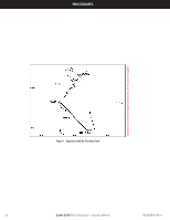
GROUND LESSONS Ground Lesson 11 DATA WEATHER LINK Objectives Upon completion of this lesson, the pilot should be able to understand and interpret weather information displayed in the cockpit. The pilot will be able to use this information as supporting information to enhance the decision making process before and during the flight. Resources • G1000 Pilot's Guide • G1000 PC-based Simulator • www.xmradio.com • www.wxworx.com Exercise 11.1: Weather and Digital Audio Entertainment 1. Briefly describe the theory of how weather and radio information are provided to the aircraft. WxWorx's current weather information is delivered through continuous satellite broadcast of data from XM's Satellite Network. Weather data is retrieved and updated constantly from WxWorx sources located at thousands of points across the nation. XM's satellite delivery solution is driven by two commercial satellites. Both satellites simultaneously transmit data and are always in view. With the XM service subscription, the GDL 69/69A receives XM Weather data and displays it on the G1000 system. 2. What types of data link weather are displayed on MFD/PFD, and what appropriate steps must be taken to get there? XM Weather information is displayed by the Multi Function Display (MFD) and Primary Flight Display (PFD). Multi Function Display 1. Navigation Map Page: By pressing the MAP softkey and then the appropriate softkeys, NEXRAD, Cell Movement, TFRs, and XM Lightning data can be displayed. 2. Nearest Pages: By turning the large FMS control knob to Nearest Pages, pressing the MAP softkey, then by pressing the appropriate softkeys, NEXRAD, Cell Movement, TFRs, and XM Lightning data can be displayed. 3. Airport Information Page: Press the WX softkey to display METAR and TAF text information. 4. AUX - Trip Planning Page Map: By pressing the MAP softkey and then pressing the appropriate softkeys, NEXRAD, Cell Movement, TFRs, and XM Lightning data are displayed. 5. Flight Plan Page Maps: By pressing the MAP softkey and then pressing the appropriate softkeys, NEXRAD, Cell Movement, TFRs, and XM Lightning data are displayed. 6. The Weather Data Link Page displays all available weather products. Turn the large FMS knob to select the Map Page Group. Turn the small FMS knob to select the Weather Data Link Page. Primary Flight Display 1. INSET Map: Press the INSET softkey and by pressing the appropriate softkeys, display NEXRAD, TFRs, and XM Lightning data. 190-00368-04 Rev. A (exercise continued on next page) Garmin G1000 Pilot's Training Guide - Instructor's Reference 21
-
 1
1 -
2
-
3
-
4
-
5
-
6
-
7
-
8
-
9
-
10
-
11
-
12
-
13
-
14
-
15
-
16
-
17
-
18
-
19
-
20
-
21
-
 22
22 -
 23
23 -
 24
24 -
 25
25 -
 26
26 -
 27
27 -
 28
28 -
 29
29 -
 30
30 -
 31
31 -
 32
32 -
33
-
34
-
35
-
36
-
37
-
38
-
39
-
40
-
41
-
42
-
43
-
44
-
45
-
46
-
47
-
48
-
49
-
50
-
51
-
52
-
53
-
54
 |
 |