Garmin G1000 Pilot's Training Guide (Instructor's Reference -04) - Page 28
What is NEXRAD? - update
 |
View all Garmin G1000 manuals
Add to My Manuals
Save this manual to your list of manuals |
Page 28 highlights
GROUND LESSONS 3. List the weather products and corresponding update rates that are available through XM Weather. NEXRAD 5 min. Cloud Tops 15 min. Cell Movement 12 min. County Warnings 5 min. METARs 12 min. AIRMETs 12 min. TAFs 12 min. SIGMETs 12 min. Lightning 5 min. Echo Tops 7.5 min. TFRs 12 min. Winds Aloft 12 min. Surface Analysis 12 min. 4. Reported/forecast products use a date/time stamp. On what are the date and time based? Date and time are based on Zulu time as reported by appropriate weather stations, not on when the data is received by the data link sensor. 5. When and how is weather data information received?. Before the GDL 69/69A can be used, the XM Satellite Radio subscription must be activated. XM Satellite Radio offers several subscriptions at different service levels. Refer to the XM Satellite Radio website for information regarding subscription options. 6. What type of lightning strike information does XM Weather provide? Only cloud-to-ground lightning is provided by XM. To receive cloud-to-cloud lightning strike information, the aircraft must be equipped with additional lightning detection equipment, such as Stormscope. 7. What is NEXRAD? NEXRAD (NEXt generation RADar) is a Doppler radar system that has greatly improved the detection of meteorological events such as thunderstorms, tornadoes, and hurricanes. 8. What are the coverage areas of the XM Satellite signal? At what altitude must the aircraft fly to receive the XM signal? The XM signal provides full coverage of the continental United States. The information can be received on the ground and while flying at any altitude throughout North America. 9. A pilot is planning a cross-county flight. Does weather data provided by WxWorx satisfy FAR 91.103 prefight action? No, weather data received in the cockpit is not approved to satisfy FAR 91.103. One must receive approved weather data from the National Weather Service/FSS. Use data link weather as a supporting reference only. XM Weather is not to be used as a main source for making decisions before or during flight. 10. A pilot is on a VFR flight from KXYZ to KABC. Currently, the altitude is 9,500 feet, 50 miles from KABC. Weather is predicted to be MVFR at the destination airport. Using the MFD, describe the steps that must be taken to receive a METAR and/or TAF at the destination airport. 1. Navigation Map Page: Turn the small FMS knob to the right until the Weather Data Link page is displayed. 2. Press the METAR softkey to display colored flags at the airports. 3. Press the LEGEND softkey to see descriptions of graphic symbols and color codes. 4. Turn the large FMS knob to the WPT page group. 5. Turn the small FMS knob to select the Airport Information Page. 6. Select the destination airport and press the WX softkey to display METAR and TAF text. 22 Garmin G1000 Pilot's Training Guide - Instructor's Reference 190-00368-04 Rev. A
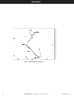
-
 1
1 -
2
-
3
-
4
-
5
-
6
-
7
-
8
-
9
-
10
-
11
-
12
-
13
-
14
-
15
-
16
-
17
-
18
-
19
-
20
-
21
-
22
-
 23
23 -
 24
24 -
 25
25 -
 26
26 -
 27
27 -
 28
28 -
 29
29 -
 30
30 -
 31
31 -
 32
32 -
 33
33 -
34
-
35
-
36
-
37
-
38
-
39
-
40
-
41
-
42
-
43
-
44
-
45
-
46
-
47
-
48
-
49
-
50
-
51
-
52
-
53
-
54
 |
 |