Magellan RoadMate 6000T Manual - English - Page 117
GPS Status Screen
 |
UPC - 763357115055
View all Magellan RoadMate 6000T manuals
Add to My Manuals
Save this manual to your list of manuals |
Page 117 highlights
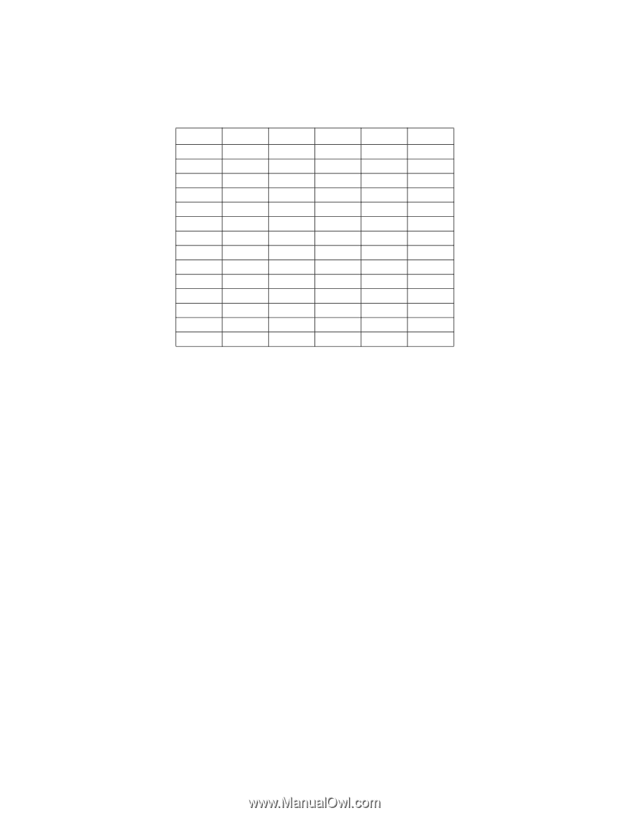
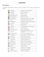
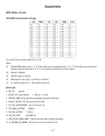
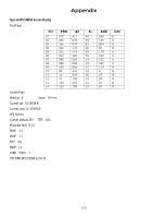
Appendix GPS Status Screen GPS STATUS Screen Structure-first page CH 01 02 03 04 05 06 07 08 09 10 11 12 13 14 PRN d1 d1 d1 d1 d1 d1 d1 d1 d1 d1 d1 d1 d1 d1 AZ d2 d2 d2 d2 d2 d2 d2 d2 d2 d2 d2 d2 d2 d2 EL d3 d3 d3 d3 d3 d3 d3 d3 d3 d3 d3 d3 d3 d3 SNR d4 d4 d4 d4 d4 d4 d4 d4 d4 d4 d4 d4 d4 d4 U/N c1 c1 c1 c1 c1 c1 c1 c1 c1 c1 c1 c1 c1 c1 It is ordered by the channel number from 1 to 12. Where: d1: Satellite PRN number, with "e" or "E" to the right means got ephemeris data, "v" or "V" to the right means got verified ephemeris data (double check). "E" or "V" also means got satellite time for this channel. d2: Azimuth, in degrees d3: Elevation angle, in degrees d4: SNR (signal to noise ratio), it is ratio-Hz, not dB unit c1: U - Used for position fix, U - Not used for position fix Bad fix code 0 PVT_OK :good fix 2 ILLEGAL_ALT: illegal altitude < -10km or > 17.5km 4 POSITION_JUMP: too big position jump between two epoch (300 miles) 5 ILLEGAL_VELOCITY_OR_ALT: max velocity 951mile 7 TOO_BIG_ACCELERATION max 15m around 1.5g 8 TOO_SMALL_ALTITUDE -10000 m 9 TOO_BIG_ALTITUDE 17,500 m 10 TOO_BIG_PDOP max PDOP 50 11 SATS_BELOW_MASK_ANGLE satellite elevation angle is below mask angle 16 ILL_DEFINED_3D_MATRIX 3X3 matrix can not be inverted in 3D fix 107
-
 1
1 -
2
-
3
-
4
-
5
-
6
-
7
-
8
-
9
-
10
-
11
-
12
-
13
-
14
-
15
-
16
-
17
-
18
-
19
-
20
-
21
-
22
-
23
-
24
-
25
-
26
-
27
-
28
-
29
-
30
-
31
-
32
-
33
-
34
-
35
-
36
-
37
-
38
-
39
-
40
-
41
-
42
-
43
-
44
-
45
-
46
-
47
-
48
-
49
-
50
-
51
-
52
-
53
-
54
-
55
-
56
-
57
-
58
-
59
-
60
-
61
-
62
-
63
-
64
-
65
-
66
-
67
-
68
-
69
-
70
-
71
-
72
-
73
-
74
-
75
-
76
-
77
-
78
-
79
-
80
-
81
-
82
-
83
-
84
-
85
-
86
-
87
-
88
-
89
-
90
-
91
-
92
-
93
-
94
-
95
-
96
-
97
-
98
-
99
-
100
-
101
-
102
-
103
-
104
-
105
-
106
-
107
-
108
-
109
-
110
-
111
-
 112
112 -
 113
113 -
 114
114 -
 115
115 -
 116
116 -
 117
117 -
 118
118 -
 119
119 -
 120
120 -
 121
121
 |
 |