Garmin GPS 12XL Owner's Manual (Software Version 4.0 and above) - Page 11
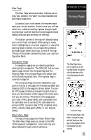
Map Navigation Main Menu
 |
UPC - 753759007034
View all Garmin GPS 12XL manuals
Add to My Manuals
Save this manual to your list of manuals |
Page 11 highlights
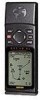
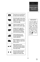
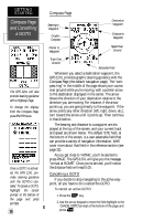
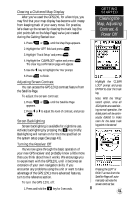
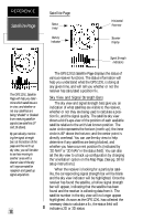
Map Page The Map Page acts as a window. It allows you to view your position, the "path" you have traveled over, and nearby waypoints. A diamond icon in the center of the screen represents your current position. As you move, you will see a thin line-called a track log-appear along the path you have just covered. Names of stored waypoints and nearby cities can also be shown on the map. The bottom corners of the map will always display your current track and speed. When going to a waypoint, highlighting an on-screen waypoint, or using the panning target crosshair, the corresponding distance and bearing are shown at the top corners of the map. The top of the screen contains the zoom, pan, and configuration fields. Navigation Page A navigation page gives you steering guidance when going to a waypoint. The GPS 12XL has two navigation page choices: the Compass Page and the Highway Page. The Compass Page is the default and will be briefly explained here. The Highway Page is covered on page 34. The Compass Page shows the destination waypoint at the top of the page with the bearing (BRG) and distance (DST) to the waypoint shown below. The center of the page contains a compass ring and arrow to show you the direction of the waypoint from the direction you are moving. The bottom of the page gives your track (TRK), speed (SPD), and a selectable field for estimated time to arrival (ETA), estimated time enroute (ETE), course to steer (CTS), crosstrack error, (XTK), velocity made good (VMG), or turn bearing (TRN). Main Menu Page The last primary page is the Main Menu Page. The Main Menu Page gives you access to the GPS 12XL's waypoint management, route, track log, and setup features through a list of submenus. INTRODUCTION Primary Pages Map Page The Map Page shows your progress on a moving map plotter and gives a bird's-eye-view of surrounding waypoints and cities. Compass Page The Compass Page is the default navigation page and will show you the way to the waypoint from the direction you are moving. 7
-
 1
1 -
2
-
3
-
4
-
5
-
 6
6 -
 7
7 -
 8
8 -
 9
9 -
 10
10 -
 11
11 -
 12
12 -
 13
13 -
 14
14 -
 15
15 -
 16
16 -
17
-
18
-
19
-
20
-
21
-
22
-
23
-
24
-
25
-
26
-
27
-
28
-
29
-
30
-
31
-
32
-
33
-
34
-
35
-
36
-
37
-
38
-
39
-
40
-
41
-
42
-
43
-
44
-
45
-
46
-
47
-
48
-
49
-
50
-
51
-
52
-
53
-
54
-
55
-
56
-
57
-
58
-
59
-
60
-
61
-
62
-
63
-
64
-
65
-
66
 |
 |
