Garmin GPS 12XL Owner's Manual (Software Version 4.0 and above) - Page 49
Navigation Setup: Units of Measure
 |
UPC - 753759007034
View all Garmin GPS 12XL manuals
Add to My Manuals
Save this manual to your list of manuals |
Page 49 highlights
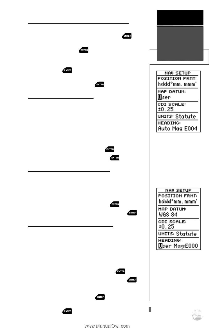
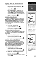
Navigation Setup: Map Datums (continued) To define a user datum: 1. Highlight the 'MAP DATUM' field, and press . 2. Scroll through the map datum options until 'User' appears, and press . 3. Enter the five parameters of the map datum-'DX', 'DY', 'DZ', 'DA', and 'DF'-using the rocker keypad, and press . The signs of each value should follow the convention: WGS 84 +/- local geodetic system. 4. Highlight 'SAVE?', and press . Navigation Setup: CDI Scale The course deviation indicator (CDI) field lets you select the range of the CDI bar scale on the Highway Page. Four scales are available: +/- 0.02, 0.25 (default), 1.25, and 5.0 miles or kilometers. Note: This CDI value represents the full scale limits (left or right from center) of the CDI. To enter a CDI scale setting: 1. Highlight the 'CDI' field, and press . 2. Select the desired setting, and press . Navigation Setup: Units of Measure The GPS 12XL lets you select statute (default), nau- tical, or metric units of measure for all speed and distance readouts. To change the unit of measure: 1. Highlight the 'UNITS' field, and press . 2. Select the desired units of measure, and press . Navigation Setup: Heading Reference The GPS 12XL's heading information can be dis- played referencing magnetic north (automatic or userdefined), true north, or calculated grid headings. The default setting is automatically-calculated magnetic north, which is suitable for most applications. To select a heading reference: 1. Highlight the 'HEADING' field, and press . 2. Select the desired heading reference, and press . To enter a user-defined magnetic heading: . 1. Select 'User Mag' and press . 2. Enter the degrees and direction of magnetic variation, and press . REFERENCE Navigation Setup The user datum feature allows you to define the earth model used to calculate position coordinates. WARNING: Incorrect entries may result in substantial position errors. To enter a user-defined magnetic variation, select the 'User Mag' option and enter the desired direction and degrees. 45
-
 1
1 -
2
-
3
-
4
-
5
-
6
-
7
-
8
-
9
-
10
-
11
-
12
-
13
-
14
-
15
-
16
-
17
-
18
-
19
-
20
-
21
-
22
-
23
-
24
-
25
-
26
-
27
-
28
-
29
-
30
-
31
-
32
-
33
-
34
-
35
-
36
-
37
-
38
-
39
-
40
-
41
-
42
-
43
-
 44
44 -
 45
45 -
 46
46 -
 47
47 -
 48
48 -
 49
49 -
 50
50 -
 51
51 -
 52
52 -
 53
53 -
 54
54 -
55
-
56
-
57
-
58
-
59
-
60
-
61
-
62
-
63
-
64
-
65
-
66
 |
 |