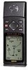
Garmin GPS 12XL Owner's Manual (Software Version 4.0 and above) - Page 45
Find City &, City Setup
 |
UPC - 753759007034
View all Garmin GPS 12XL manuals
Add to My Manuals
Save this manual to your list of manuals |
Page 45 highlights
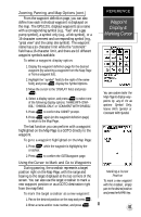
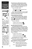
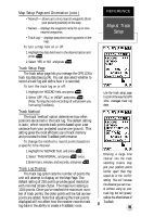
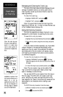
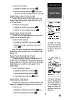
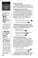
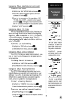
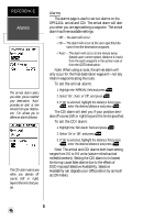
To GOTO the city location from the find city page: 1. Highlight 'GOTO' at the bottom of the page and press twice. City Setup Page The city setup page lets you select the zoom range where city locations become visible on the map. The cities are divided into three categories: large, medium and small. (Large cities are those with approximate populations greater than 100,000. Medium cities are those with approximate populations over 5,000.) To set the visible range for cities: 1. Highlight the desired city size field and press . 2. Select the desired map scale and press . Main Menu Page The GPS 12XL's Main Menu Page (shown on pgs. 18 and 27) provides access to additional pages (submenus) that are used to customize operation and select navigation/planning features. These nine pages are divided into categories by function. We've already gone over the waypoint and route management pages in their respective sections. Let's review the rest of these pages in the order they appear on the Main Menu Page. To select a submenu page from the Main Menu: 1. Highlight the submenu option, and press . 2. To return to the Main Menu Page, press . Distance and Sun Calculations The distance and sun calculation page will give you the distance and bearing between any two waypoints or between your present position and a waypoint. It will also calculate the sunrise and sunset (in local time) for a particular date at either your present position or any stored waypoint. To perform a distance and sun calculation: 1. Highlight the 'FROM' field, press , enter the desired waypoint, and press again. 2. Highlight the 'TO' field, press , enter the destina- tion waypoint, and press again. 3. Highlight the 'DATE' field. press and enter the date you'll arrive at your destination. Press again. If you haven't marked your present position as a waypoint, just leave the 'TO' field blank to show the sunrise and sunset at your present position. REFERENCE Find City & City Setup Configure at which map scales city locations will appear on the Map Page, using the city setup page. The 'zoom' setting indicates the maximum scale at which the cities appear. The GPS12XL will calculate the sunrise and sunset times of any stored waypoint or your present position. To calculate, enter the date and year, then press ENTER. 41
-
 1
1 -
2
-
3
-
4
-
5
-
6
-
7
-
8
-
9
-
10
-
11
-
12
-
13
-
14
-
15
-
16
-
17
-
18
-
19
-
20
-
21
-
22
-
23
-
24
-
25
-
26
-
27
-
28
-
29
-
30
-
31
-
32
-
33
-
34
-
35
-
36
-
37
-
38
-
39
-
 40
40 -
 41
41 -
 42
42 -
 43
43 -
 44
44 -
 45
45 -
 46
46 -
 47
47 -
 48
48 -
 49
49 -
 50
50 -
51
-
52
-
53
-
54
-
55
-
56
-
57
-
58
-
59
-
60
-
61
-
62
-
63
-
64
-
65
-
66
 |
 |
