Garmin GPSMAP 178C Owners Manual - Page 27
Highway To adjust the simulated boat speed/heading from the Highway
 |
UPC - 753759043544
View all Garmin GPSMAP 178C manuals
Add to My Manuals
Save this manual to your list of manuals |
Page 27 highlights
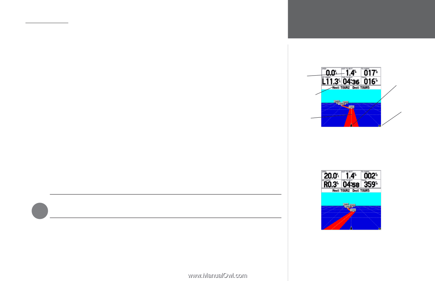
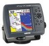
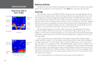
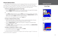
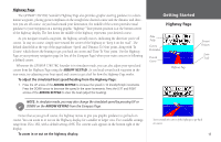
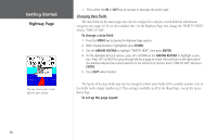
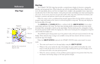
Highway Page The GPSMAP 178/178C Sounder's Highway Page also provides graphic steering guidance to a destination waypoint, placing greater emphasis on the straight-line desired course and the distance and direction you are off course. As you head toward your destination, the middle of the screen provides visual guidance to your waypoint on a moving graphic "highway." Your present position is at the bottom center of the highway display. The line down the middle of the highway represents your desired course. As you navigate toward a waypoint, the highway actually moves, indicating the direction you're off course. To stay on course, simply steer toward the center of the highway or "keep it on the road". The default data fields at the top of the page indicate 'Speed' and 'Distance To Next' point, along with 'To Course' which shows the bearing to get you back on course and 'Time To Next' point. Use the Highway Page as your primary navigation page (in lieu of the Compass Page) when your main concern is following a defined course. Whenever the GPSMAP 178/178C Sounder is in simulator mode, you can also adjust your speed and course from the Highway Page using the ARROW KEYPAD. As you head toward each waypoint in the tour route, try adjusting your boat speed and course to get a feel for how the Highway Page works. To adjust the simulated boat speed/heading from the Highway Page: 1. Press the UP arrow of the ARROW KEYPAD to increase the speed in 10 knot/kph/mph increments. Press the DOWN arrow to decrease the speed in the same increments. Press the LEFT and RIGHT arrows of the ARROW KEYPAD to steer the boat (adjust the heading). Getting Started Highway Page Data Fields Current Destination Desired Course Highway Page Present Position Zoom Scale NOTE: In simulator mode, you may also change the simulated speed by pressing UP or F DOWN on the ARROW KEYPAD from the Compass Page. Notice that as you get off course, the highway moves to give you graphic guidance to get back on course. You can zoom in or out on the Highway display for a smaller or larger view. Five available settings range from 1X to 16X, with a default setting of 8X. The current scale appears in the bottom right of the display. To zoom in or out on the highway display: Steer towards the center of the highway to get back on course. 17
-
 1
1 -
2
-
3
-
4
-
5
-
6
-
7
-
8
-
9
-
10
-
11
-
12
-
13
-
14
-
15
-
16
-
17
-
18
-
19
-
20
-
21
-
 22
22 -
 23
23 -
 24
24 -
 25
25 -
 26
26 -
 27
27 -
 28
28 -
 29
29 -
 30
30 -
 31
31 -
 32
32 -
33
-
34
-
35
-
36
-
37
-
38
-
39
-
40
-
41
-
42
-
43
-
44
-
45
-
46
-
47
-
48
-
49
-
50
-
51
-
52
-
53
-
54
-
55
-
56
-
57
-
58
-
59
-
60
-
61
-
62
-
63
-
64
-
65
-
66
-
67
-
68
-
69
-
70
-
71
-
72
-
73
-
74
-
75
-
76
-
77
-
78
-
79
-
80
-
81
-
82
-
83
-
84
-
85
-
86
-
87
-
88
-
89
-
90
-
91
-
92
-
93
-
94
-
95
-
96
-
97
-
98
-
99
-
100
-
101
-
102
-
103
-
104
-
105
-
106
-
107
-
108
-
109
-
110
-
111
-
112
-
113
-
114
-
115
-
116
-
117
-
118
-
119
-
120
-
121
-
122
-
123
-
124
-
125
-
126
-
127
-
128
-
129
-
130
-
131
-
132
-
133
-
134
 |
 |