Garmin GPSMAP 60CS Owner's Manual - Page 46
ENTER, ROCKER, Find By Name, Find Nearest, Select Symbol, Change Reference
 |
UPC - 753759044060
View all Garmin GPSMAP 60CS manuals
Add to My Manuals
Save this manual to your list of manuals |
Page 46 highlights
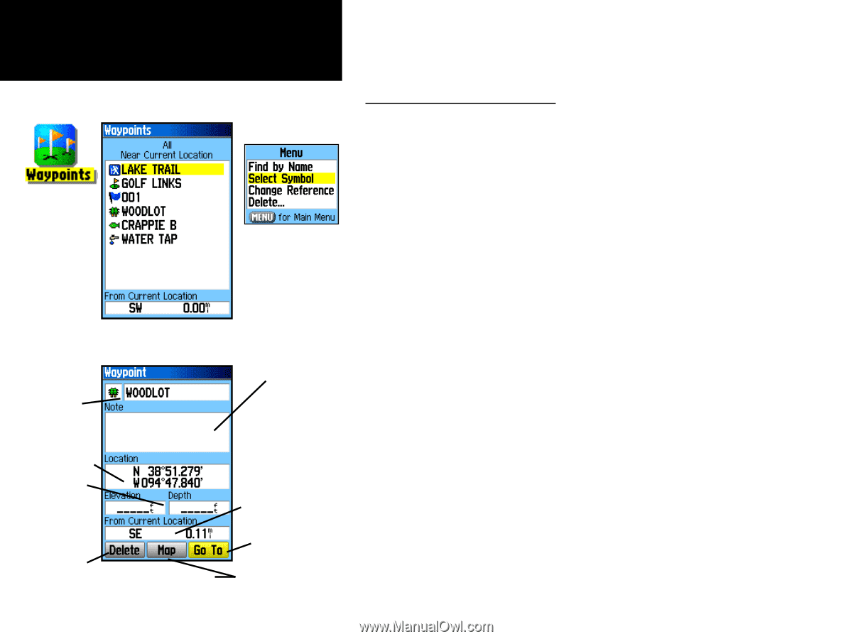
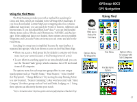
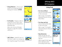
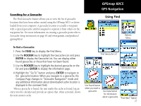
GPSmap 60CS GPS Navigation Using Find Find Waypoint Options Find Waypoints List Waypoint Information Page Waypoint Name and Symbol Enter a notation using the Waypoint Location on-screen keypad Coordinates, Elevation and Depth (if applicable) Distance and Direction from Current Location Navigate to Remove a Waypoint Waypoint from List 36 View Waypoint on Map Page Location Searching for a Waypoint The Waypoints List is your storage file for all created and saved waypoints. Waypoints can be created from marking your location, pointing to a place on the map or saving any other Find item (i.e. city, restaurant) as a waypoint. Waypoints are stored in alpha/numerical order and are also identified by a symbol assigned from a list of symbol types. Waypoints can be selected as destinations and added as points on a route. To find a Waypoint: 1. Press the FIND key to display the Find Menu. 2. Highlight the Waypoint icon and press ENTER to display the Waypoints List. 3. Use the ROCKER key to scroll up and down the list to find a waypoint. If the list is large, you can press the MENU key to display a list of search options. Find By Name: allows you to enter the name of the waypoint in a search field. Find Nearest: allows you to list only those waypoints near your current location. Select Symbol: allows you to search for only those waypoints of a specific type. Change Reference: allows you to use the Panning Arrow to select a point on the map other than your current location. 4. Once found, a waypoint information page can be viewed by pressing the ENTER key. The data can be edited or select "Go To" to navigate to a waypoint.
-
 1
1 -
2
-
3
-
4
-
5
-
6
-
7
-
8
-
9
-
10
-
11
-
12
-
13
-
14
-
15
-
16
-
17
-
18
-
19
-
20
-
21
-
22
-
23
-
24
-
25
-
26
-
27
-
28
-
29
-
30
-
31
-
32
-
33
-
34
-
35
-
36
-
37
-
38
-
39
-
40
-
 41
41 -
 42
42 -
 43
43 -
 44
44 -
 45
45 -
 46
46 -
 47
47 -
 48
48 -
 49
49 -
 50
50 -
 51
51 -
52
-
53
-
54
-
55
-
56
-
57
-
58
-
59
-
60
-
61
-
62
-
63
-
64
-
65
-
66
-
67
-
68
-
69
-
70
-
71
-
72
-
73
-
74
-
75
-
76
-
77
-
78
-
79
-
80
-
81
-
82
-
83
-
84
-
85
-
86
-
87
-
88
-
89
-
90
-
91
-
92
-
93
-
94
-
95
-
96
-
97
-
98
-
99
-
100
-
101
-
102
-
103
-
104
-
105
-
106
-
107
-
108
 |
 |