Garmin GPSMap 498 Owner's Manual - Page 38
Cartography, Map Options, To change data field contents and configuration - data card
 |
UPC - 753759052171
View all Garmin GPSMap 498 manuals
Add to My Manuals
Save this manual to your list of manuals |
Page 38 highlights
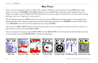
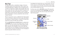
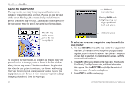
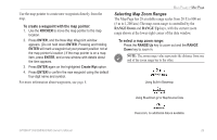
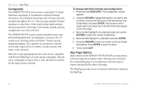
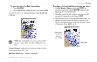
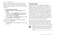
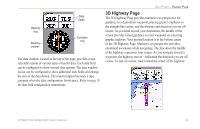
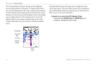
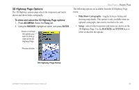
MAIN PAGES > MAP PAGE Cartography The GPSMAP 392/398 system contains a preloaded U.S. inland freshwater cartography to its enhanced worldwide basemap information. The preloaded inland maps offer 50-meter shoreline resolution throughout the U.S., with even more detailed 10-meter resolution on select lakes. Other details include depth contours, tide and current data, boat ramps, mile markers, hazards, marinas, campgrounds, area roads, and more. The GPSMAP 492/498 system contains preloaded marine map detail utilizing BlueChart® g2 technology. Coverage is for U.S. coastal areas, including Alaska and Hawaii. Features include integrated mapping, 2D or mariner's eye perspective, tide and current data, improved IALA symbols, navaids, marinas, boat ramps, roads, and more. Both units accept preprogrammed data cards and are compatible with the latest BlueChart® g2 series marine cartography. The unit shows cartography as long as there is chart information available for the range you have selected. To change data field contents and configuration: 1. Press and hold DATA/CNFG. The Configuration window appears. 2. Using the ROCKER, highlight the function you want to add or remove, such as the status bar or first and second rows of data fields, and press ENTER. Only functions with a check mark in the check box to the left of the name appear on the main page. 3. Move the field highlight to the data field slider and use the ROCKER to select the number of data fields. 4. Move the field highlight to a data field, and press ENTER. 5. Using the ROCKER to move up or down on the list of data field options. Press ENTER to select an option. 6. To exit, press QUIT. Map Page Options Many features of the GPSMAP 392/398/492/498 are menu driven. Each main page has an options menu, allowing you to customize the corresponding page to your preferences and select special features that specifically relate to that page. The Map Page provides access to functions and features relating to the Map Page. 30 GPSMAP 392/398/492/498 Owner's Manual
-
 1
1 -
2
-
3
-
4
-
5
-
6
-
7
-
8
-
9
-
10
-
11
-
12
-
13
-
14
-
15
-
16
-
17
-
18
-
19
-
20
-
21
-
22
-
23
-
24
-
25
-
26
-
27
-
28
-
29
-
30
-
31
-
32
-
 33
33 -
 34
34 -
 35
35 -
 36
36 -
 37
37 -
 38
38 -
 39
39 -
 40
40 -
 41
41 -
 42
42 -
 43
43 -
44
-
45
-
46
-
47
-
48
-
49
-
50
-
51
-
52
-
53
-
54
-
55
-
56
-
57
-
58
-
59
-
60
-
61
-
62
-
63
-
64
-
65
-
66
-
67
-
68
-
69
-
70
-
71
-
72
-
73
-
74
-
75
-
76
-
77
-
78
-
79
-
80
-
81
-
82
-
83
-
84
-
85
-
86
-
87
-
88
-
89
-
90
-
91
-
92
-
93
-
94
-
95
-
96
-
97
-
98
-
99
-
100
-
101
-
102
-
103
-
104
-
105
-
106
-
107
-
108
-
109
-
110
-
111
-
112
-
113
-
114
-
115
-
116
-
117
-
118
-
119
-
120
-
121
-
122
 |
 |