Garmin GPSMap 498 Owner's Manual - Page 90
Transducer Coverage, Scale, Overlay, Corners, Basic, No Scale, Water, Temperature Number - front cover
 |
UPC - 753759052171
View all Garmin GPSMap 498 manuals
Add to My Manuals
Save this manual to your list of manuals |
Page 90 highlights
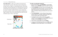
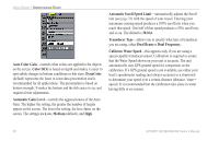
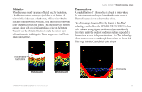
USING SONAR > UNDERSTANDING SONAR • Scale-controls the appearance of the depth scale shown vertically along the right side of the graph. You can configure the depth scale to appear in one of four different ways: as an Overlay, in the Corners, Basic, or No Scale. • Water Temperature Number and Water Speed Number- hides or shows temperature and water speed on the Sonar Page. When set to Auto, the unit automatically shows this information, only if it is received from the transducer. • Color Scheme-sets the colors for the Sonar and Flasher Pages. NOTE: If the unit is unable to track the bottom for any reason, the digits in the depth window flash on and off to alert you that the unit is not tracking the bottom. Transducer Coverage The area covered by the transmitted sound waves is determined by the cone angle of the transducer and the water depth. The wide cone angles (40°) associated with low frequencies (50 kHz/80kHz) provide a large coverage area for finding fish within a coverage width that is approximately 2/3 of the water depth. However, this also means that wide cone angles produce less bottom detail and resolution. As shown in the drawing on page 73, the 40° cone angle produces a coverage area of approximately a 20-foot diameter circle at a 30-foot depth. The narrow cone angles (10°) associated with the high frequencies (200 kHz) provide better bottom resolution and crisper detail, but cannot show a large coverage area for finding fish. The 10° cone angle provides a coverage width that is approximately 2/10 of the water depth. As shown in the drawing on the far right, the 10° cone angle produces a coverage area of approximately a 6-foot diameter circle at a 30-foot depth. Dual frequency or dual beam modes combine both frequencies to get the best coverage area and contour/depth readings. 82 GPSMAP 392/398/492/498 Owner's Manual
-
 1
1 -
2
-
3
-
4
-
5
-
6
-
7
-
8
-
9
-
10
-
11
-
12
-
13
-
14
-
15
-
16
-
17
-
18
-
19
-
20
-
21
-
22
-
23
-
24
-
25
-
26
-
27
-
28
-
29
-
30
-
31
-
32
-
33
-
34
-
35
-
36
-
37
-
38
-
39
-
40
-
41
-
42
-
43
-
44
-
45
-
46
-
47
-
48
-
49
-
50
-
51
-
52
-
53
-
54
-
55
-
56
-
57
-
58
-
59
-
60
-
61
-
62
-
63
-
64
-
65
-
66
-
67
-
68
-
69
-
70
-
71
-
72
-
73
-
74
-
75
-
76
-
77
-
78
-
79
-
80
-
81
-
82
-
83
-
84
-
 85
85 -
 86
86 -
 87
87 -
 88
88 -
 89
89 -
 90
90 -
 91
91 -
 92
92 -
 93
93 -
 94
94 -
 95
95 -
96
-
97
-
98
-
99
-
100
-
101
-
102
-
103
-
104
-
105
-
106
-
107
-
108
-
109
-
110
-
111
-
112
-
113
-
114
-
115
-
116
-
117
-
118
-
119
-
120
-
121
-
122
 |
 |