Garmin GPSMap 498 Owner's Manual - Page 89
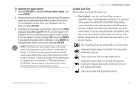
Graph Sub Tab, To calibrate the water speed
 |
UPC - 753759052171
View all Garmin GPSMap 498 manuals
Add to My Manuals
Save this manual to your list of manuals |
Page 89 highlights
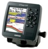
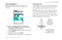
To calibrate the water speed: 1. Use the ROCKER to highlight Calibrate Water Speed, and press ENTER. 2. Bring the boat to a cruising speed. Both the top GPS ground speed and uncalibrated water speed appear at the bottom of the calibration window. Note your top speed, stop the boat, and press ENTER. 3. By default, the top speed automatically appears in the What was your top water speed? field. If a ground speed is not available, the top uncalibrated water speed is used instead. If the new speed is correct, highlight OK, and press ENTER. If you want to manually enter a calibration, press ENTER on the speed field, enter a new speed, and press ENTER. NOTE: If the boat is not moving fast enough or the speed sensor is not registering a speed, a "Boat Is Not Moving Fast Enough To Calibrate" message appears at the bottom of the screen. Check that the speed sensor wheel is moving or safely increase boat speed. If there is a problem with the speed sensor, or if a speed senor is not installed, a "Water Speed Sensor Is Not Working" message appears at the bottom of the screen. Check the connections of the speed sensor cables. USING SONAR > UNDERSTANDING SONAR Graph Sub Tab The available Graph sub tab options are: • Fish Symbols-sets how the Sonar Page interprets suspended targets and background information. If you select a fish symbol, the GPSMAP 392/398/492/498 identifies some returns for you by replacing them with fish symbols (in large, medium, and small sizes based on the size of the sonar return). If you are using dual beam, fish symbols from the narrow beam (directly underneath your boat) are solid, and the returns from the wide beam (out to the sides of your boat) are hollow. The Sonar Page does not interpret the sonar return data. Suspended targets appear as symbols. No background information appears Same as previous with the target depth shown. Suspended targets appear as symbols. Background information appears, making the distinction between fish and structure easier. Same as previous with target depth shown. GPSMAP 392/398/492/498 Owner's Manual 81
-
 1
1 -
2
-
3
-
4
-
5
-
6
-
7
-
8
-
9
-
10
-
11
-
12
-
13
-
14
-
15
-
16
-
17
-
18
-
19
-
20
-
21
-
22
-
23
-
24
-
25
-
26
-
27
-
28
-
29
-
30
-
31
-
32
-
33
-
34
-
35
-
36
-
37
-
38
-
39
-
40
-
41
-
42
-
43
-
44
-
45
-
46
-
47
-
48
-
49
-
50
-
51
-
52
-
53
-
54
-
55
-
56
-
57
-
58
-
59
-
60
-
61
-
62
-
63
-
64
-
65
-
66
-
67
-
68
-
69
-
70
-
71
-
72
-
73
-
74
-
75
-
76
-
77
-
78
-
79
-
80
-
81
-
82
-
83
-
 84
84 -
 85
85 -
 86
86 -
 87
87 -
 88
88 -
 89
89 -
 90
90 -
 91
91 -
 92
92 -
 93
93 -
 94
94 -
95
-
96
-
97
-
98
-
99
-
100
-
101
-
102
-
103
-
104
-
105
-
106
-
107
-
108
-
109
-
110
-
111
-
112
-
113
-
114
-
115
-
116
-
117
-
118
-
119
-
120
-
121
-
122
 |
 |