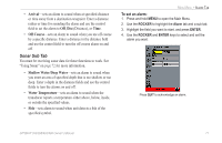
Garmin GPSMap 498 Owner's Manual - Page 81
Understanding the Sonar Display, solid colors blue is the default. - cover
 |
UPC - 753759052171
View all Garmin GPSMap 498 manuals
Add to My Manuals
Save this manual to your list of manuals |
Page 81 highlights
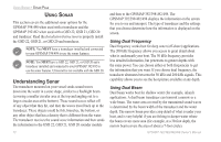
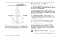
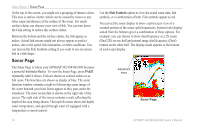
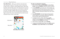
Narrow Beam Wide Beam The wide beam is more helpful in shallow water, because it gives you a much wider view of objects in the water, including areas beyond the sides of your boat. At a 30-foot depth, the wide beam covers the area of approximately a 20-foot circle. GPSMAP 392/398/492/498 Owner's Manual USING SONAR > SONAR PAGE Understanding the Sonar Display One of the first things to understand about sonar is that the transducer sends a beam down to the bottom of the water, much like the beam of a flashlight. The beam starts small near your vessel and expands as it gets to the bottom. The Sonar Page does not show a 3-D representation of the underwater environment. Instead, the display is in two dimensions, much like if you took a picture of an aquarium. Only the depth of the item in the water is shown. The strongest sonar returns appear on your screen as the most intense solid color (depending on your selected color scheme; red is the default). The weakest returns appear as the less intense, less solid colors (blue is the default). The bottom of the water is always be the strongest signal, and therefore the most intense color. The bottom is the continuous, intensely-colored line running across the bottom of the screen. The GPSMAP 392/398/492/498 uses the latest technology in interpreting bottom signals; it can see through fish, structures, and thermoclines (shown in the weakest colors). However, large schools of fish or dense structures close to the bottom can affect water depth return readings. NOTE: If the GPSMAP 392/398/492/498 is unable to track the bottom for any reason, the digits in the depth window flash on and off to alert you that the unit is not tracking the bottom. 73
-
 1
1 -
2
-
3
-
4
-
5
-
6
-
7
-
8
-
9
-
10
-
11
-
12
-
13
-
14
-
15
-
16
-
17
-
18
-
19
-
20
-
21
-
22
-
23
-
24
-
25
-
26
-
27
-
28
-
29
-
30
-
31
-
32
-
33
-
34
-
35
-
36
-
37
-
38
-
39
-
40
-
41
-
42
-
43
-
44
-
45
-
46
-
47
-
48
-
49
-
50
-
51
-
52
-
53
-
54
-
55
-
56
-
57
-
58
-
59
-
60
-
61
-
62
-
63
-
64
-
65
-
66
-
67
-
68
-
69
-
70
-
71
-
72
-
73
-
74
-
75
-
 76
76 -
 77
77 -
 78
78 -
 79
79 -
 80
80 -
 81
81 -
 82
82 -
 83
83 -
 84
84 -
 85
85 -
 86
86 -
87
-
88
-
89
-
90
-
91
-
92
-
93
-
94
-
95
-
96
-
97
-
98
-
99
-
100
-
101
-
102
-
103
-
104
-
105
-
106
-
107
-
108
-
109
-
110
-
111
-
112
-
113
-
114
-
115
-
116
-
117
-
118
-
119
-
120
-
121
-
122
 |
 |
