Garmin GPSMap 498 Owner's Manual - Page 46
Searching for Satellites, Ready for Navigation, Ready for Nav with WAAS, Simulating - updates
 |
UPC - 753759052171
View all Garmin GPSMap 498 manuals
Add to My Manuals
Save this manual to your list of manuals |
Page 46 highlights
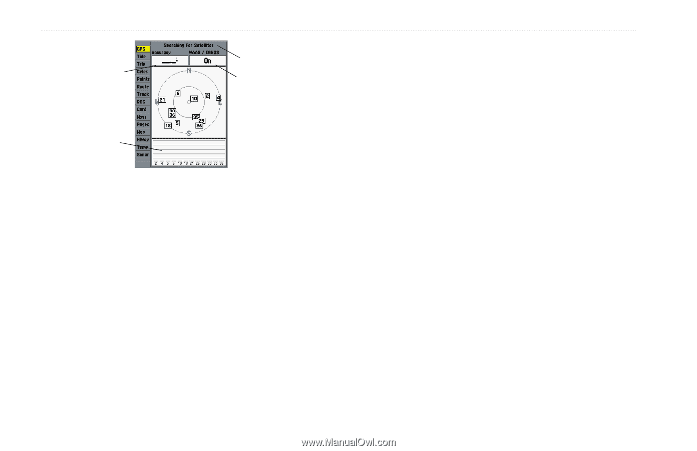
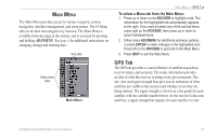
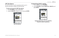
MAIN MENU > GPS TAB Accuracy Receiver status WAAS status Signal strength bars The status field indicates "Ready for Navigation" when the GPSMAP 392/398/492/498 has collected the necessary data from satellites to calculate a fix. The unit then updates the location, date, and time. You can use the sky view to help determine if any satellites are being blocked, and whether you have a current location fix. The sky view shows a bird's-eye view of the position of each satellite relative to the receiver's last known location. The outer circle represents the horizon (north up), the inner circle 45º above the horizon, and the center point a position directly overhead. You can also set the sky view to a Track up configuration, causing the top of the sky view to align along your current track heading. • Searching for Satellites-the receiver is looking for and collecting data from satellites visible at its last known or initialized position, but has not collected enough data to calculate a fix. • Ready for Navigation-at least three satellites have been acquired and your location is now being calculated in latitude, longitude, and elevation. • Ready for Nav with WAAS-at least three satellites and a WAAS/EGNOS satellite have been acquired and your location is now being calculated in latitude, longitude, and elevation. • Simulating-the receiver is in Simulator Mode. 38 GPSMAP 392/398/492/498 Owner's Manual
-
 1
1 -
2
-
3
-
4
-
5
-
6
-
7
-
8
-
9
-
10
-
11
-
12
-
13
-
14
-
15
-
16
-
17
-
18
-
19
-
20
-
21
-
22
-
23
-
24
-
25
-
26
-
27
-
28
-
29
-
30
-
31
-
32
-
33
-
34
-
35
-
36
-
37
-
38
-
39
-
40
-
 41
41 -
 42
42 -
 43
43 -
 44
44 -
 45
45 -
 46
46 -
 47
47 -
 48
48 -
 49
49 -
 50
50 -
 51
51 -
52
-
53
-
54
-
55
-
56
-
57
-
58
-
59
-
60
-
61
-
62
-
63
-
64
-
65
-
66
-
67
-
68
-
69
-
70
-
71
-
72
-
73
-
74
-
75
-
76
-
77
-
78
-
79
-
80
-
81
-
82
-
83
-
84
-
85
-
86
-
87
-
88
-
89
-
90
-
91
-
92
-
93
-
94
-
95
-
96
-
97
-
98
-
99
-
100
-
101
-
102
-
103
-
104
-
105
-
106
-
107
-
108
-
109
-
110
-
111
-
112
-
113
-
114
-
115
-
116
-
117
-
118
-
119
-
120
-
121
-
122
 |
 |