Pioneer AVIC-X920BT Owner's Manual - Page 156
Displaying the Bluetooth, connection icon, Setting the current street, name display, Setting the,
 |
UPC - 884938104241
View all Pioneer AVIC-X920BT manuals
Add to My Manuals
Save this manual to your list of manuals |
Page 156 highlights
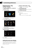
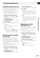
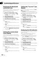
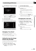
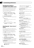
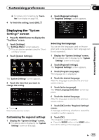
Chapter 31 Customizing preferences Displaying the Bluetooth connection icon Selects whether to display or hide the icon for current status of the phone connection via Bluetooth wireless technology. 1 Display the "Map Settings" screen. = For details, refer to Displaying the "Map Settings" screen on page 154. 2 Touch [Displayed Info]. The "Displayed Information" screen appears. 3 Touch [Bluetooth Connected]. Each time you touch the key changes that setting. ! View (default): Displays the Bluetooth connection icon on the map. ! Hide: Hides the Bluetooth connection icon on the map. = For details about the Bluetooth connection icon, refer to Bluetooth connection icon on page 26. Setting the current street name display Selects whether to display or hide the street name (or city name) that your vehicle is traveling along. 1 Display the "Map Settings" screen. = For details, refer to Displaying the "Map Settings" screen on page 154. 2 Touch [Displayed Info]. The "Displayed Information" screen appears. 3 Touch [Current Street Name]. Each time you touch the key changes that setting. ! View (default): Displays the street name (or city name) on the map. ! Hide: Hides the street name (or city name) on the map. Setting the "Favorites" icon display You can select whether to display the "Favorites" icon on the map. p Favorites icons are displayed when the map scale is 10 mile (20 kilometers) or less. = For details, refer to Editing the entry in the "Favorites" list on page 46. 1 Display the "Map Settings" screen. = For details, refer to Displaying the "Map Settings" screen on page 154. 2 Touch [Displayed Info]. The "Displayed Information" screen appears. 3 Touch [Favorites Icon]. Each time you touch the key changes that setting. ! On (default): Displays the "Favorites" icon on the map. ! Off: Hides the "Favorites" icon on the map. Displaying the 3D landmarks You can select whether to display the 3D landmark on the map. p The 3D landmarks and this setting are available for AVIC-Z120BT only. p 3D landmark only appears when the view mode is "3D View" and the map scale is set to 0.25 mile (200 m) or lower. 1 Display the "Map Settings" screen. = For details, refer to Displaying the "Map Settings" screen on page 154. 2 Touch [Displayed Info]. The "Displayed Information" screen appears. 3 Touch [3D Land Mark]. Each time you touch the key changes that setting. ! On (default): Displays the 3D landmark on the map. ! Off: Hides the 3D landmark on the map. 156 En
-
 1
1 -
2
-
3
-
4
-
5
-
6
-
7
-
8
-
9
-
10
-
11
-
12
-
13
-
14
-
15
-
16
-
17
-
18
-
19
-
20
-
21
-
22
-
23
-
24
-
25
-
26
-
27
-
28
-
29
-
30
-
31
-
32
-
33
-
34
-
35
-
36
-
37
-
38
-
39
-
40
-
41
-
42
-
43
-
44
-
45
-
46
-
47
-
48
-
49
-
50
-
51
-
52
-
53
-
54
-
55
-
56
-
57
-
58
-
59
-
60
-
61
-
62
-
63
-
64
-
65
-
66
-
67
-
68
-
69
-
70
-
71
-
72
-
73
-
74
-
75
-
76
-
77
-
78
-
79
-
80
-
81
-
82
-
83
-
84
-
85
-
86
-
87
-
88
-
89
-
90
-
91
-
92
-
93
-
94
-
95
-
96
-
97
-
98
-
99
-
100
-
101
-
102
-
103
-
104
-
105
-
106
-
107
-
108
-
109
-
110
-
111
-
112
-
113
-
114
-
115
-
116
-
117
-
118
-
119
-
120
-
121
-
122
-
123
-
124
-
125
-
126
-
127
-
128
-
129
-
130
-
131
-
132
-
133
-
134
-
135
-
136
-
137
-
138
-
139
-
140
-
141
-
142
-
143
-
144
-
145
-
146
-
147
-
148
-
149
-
150
-
 151
151 -
 152
152 -
 153
153 -
 154
154 -
 155
155 -
 156
156 -
 157
157 -
 158
158 -
 159
159 -
 160
160 -
 161
161 -
162
-
163
-
164
-
165
-
166
-
167
-
168
-
169
-
170
-
171
-
172
-
173
-
174
-
175
-
176
-
177
-
178
-
179
-
180
-
181
-
182
-
183
-
184
-
185
-
186
-
187
-
188
-
189
-
190
-
191
-
192
-
193
-
194
-
195
-
196
-
197
-
198
-
199
-
200
-
201
-
202
-
203
-
204
-
205
-
206
-
207
-
208
-
209
-
210
-
211
-
212
-
213
-
214
-
215
-
216
-
217
-
218
-
219
-
220
-
221
-
222
-
223
-
224
-
225
-
226
-
227
-
228
 |
 |
