Alpine X409-WRA-JL Navigation Users Manual - Page 15
Streets and roads, GPS position markers
 |
View all Alpine X409-WRA-JL manuals
Add to My Manuals
Save this manual to your list of manuals |
Page 15 highlights
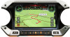
15 Freeway services By tapping it, you can check the details of the next few service stations (gas stations, restaurants) when traveling on a freeway. See page 20. 16 Parking around destination It appears near the destination. By tapping it, you can check the available parking facilities around your destination. See page 67. 17 Destination menu It appears near the destination. By tapping it, you can check the trip summary, find Places around your final destination, save the current location, or suspend the navigation. 18 Additional information It shows the Freeway services, Parking around destination, or the Destination menu button if they are available during navigation. 19 Street name It shows the current street name. By tapping it, you can open the Where Am I screen. See page 70. 20 3D objects They display hills, mountains, roads, landmarks, and buildings in 3D. By pressing the navigation hardkey button, you can open the Navigation menu, where you can reach other parts of Alpine Navigation System. If you are approaching a freeway exit or a complex intersection and the needed information exists, the map is replaced with a 3D view of the junction. See page 18. When entering a tunnel, the map is replaced with a generic tunnel image. See page 18. 2.3.1 Streets and roads Alpine Navigation System shows the streets similarly to paper road maps. Their width and colors correspond to their importance; you can easily tell a freeway from a small street. 2.3.2 GPS position markers When your GPS position is available, Alpine Navigation System marks your current position. By default, this marker is a blue arrow. The dot near the arrow shows the GPS position as perceived by the GPS receiver. When on-road navigation is selected, the current position marker may not show your exact GPS position and heading. If roads are near, it is aligned to the nearest road to eliminate GPS position errors, and the direction of the icon is aligned to the direction of the road. 15
-
 1
1 -
2
-
3
-
4
-
5
-
6
-
7
-
8
-
9
-
 10
10 -
 11
11 -
 12
12 -
 13
13 -
 14
14 -
 15
15 -
 16
16 -
 17
17 -
 18
18 -
 19
19 -
 20
20 -
21
-
22
-
23
-
24
-
25
-
26
-
27
-
28
-
29
-
30
-
31
-
32
-
33
-
34
-
35
-
36
-
37
-
38
-
39
-
40
-
41
-
42
-
43
-
44
-
45
-
46
-
47
-
48
-
49
-
50
-
51
-
52
-
53
-
54
-
55
-
56
-
57
-
58
-
59
-
60
-
61
-
62
-
63
-
64
-
65
-
66
-
67
-
68
-
69
-
70
-
71
-
72
-
73
-
74
-
75
-
76
-
77
-
78
-
79
-
80
-
81
-
82
-
83
-
84
-
85
-
86
-
87
-
88
-
89
-
90
-
91
-
92
-
93
-
94
-
95
-
96
-
97
-
98
-
99
-
100
-
101
-
102
-
103
-
104
-
105
-
106
-
107
-
108
-
109
-
110
-
111
-
112
-
113
-
114
-
115
-
116
-
117
-
118
-
119
-
120
-
121
-
122
-
123
-
124
-
125
-
126
-
127
-
128
-
129
-
130
-
131
-
132
-
133
-
134
-
135
-
136
-
137
-
138
-
139
-
140
-
141
-
142
-
143
-
144
-
145
-
146
-
147
-
148
-
149
-
150
-
151
-
152
-
153
-
154
-
155
-
156
-
157
-
158
-
159
-
160
-
161
-
162
-
163
-
164
-
165
-
166
-
167
-
168
-
169
-
170
-
171
-
172
-
173
-
174
-
175
-
176
-
177
-
178
-
179
-
180
-
181
-
182
-
183
-
184
-
185
-
186
-
187
-
188
-
189
-
190
-
191
-
192
-
193
-
194
-
195
-
196
-
197
-
198
-
199
-
200
-
201
-
202
-
203
-
204
-
205
-
206
-
207
-
208
-
209
-
210
-
211
-
212
-
213
-
214
-
215
-
216
-
217
-
218
-
219
-
220
-
221
-
222
-
223
-
224
-
225
-
226
-
227
-
228
-
229
-
230
-
231
-
232
-
233
-
234
-
235
-
236
-
237
-
238
-
239
-
240
-
241
-
242
-
243
-
244
-
245
-
246
-
247
-
248
-
249
-
250
-
251
-
252
-
253
-
254
-
255
-
256
-
257
-
258
-
259
-
260
-
261
-
262
-
263
-
264
-
265
-
266
-
267
-
268
-
269
-
270
-
271
-
272
-
273
-
274
-
275
-
276
-
277
-
278
-
279
-
280
 |
 |
