Alpine X409-WRA-JL Navigation Users Manual - Page 16
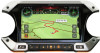
The planned route, Symbol, Description, Turn preview and next street
 |
View all Alpine X409-WRA-JL manuals
Add to My Manuals
Save this manual to your list of manuals |
Page 16 highlights
If you select Off-Road navigation, the current position marker is at your exact GPS position. The direction of the icon shows your current heading. 2.3.3 The planned route The planned route is the currently navigated route. Whenever the destination is set, the route is active until you delete it, reach your destination or suspend navigation. Alpine Navigation System displays the route in the following ways: Symbol Name Description Current GPS position and starting point It is your current position displayed on the map. If a vehicle is selected for route calculation and roads are near, the arrow jumps to the nearest road. The dot near the arrow shows the exact GPS position. Normally, if GPS position is available, the route starts from the current position. If there is no valid GPS position, Alpine Navigation System uses the last known position as the starting point. Waypoint (intermediate destination) It is an intermediate destination of the route before reaching the final destination. Destination (end point) It is the final destination of the route. Route color The route always stands out with its color on the map, both in daytime and night color modes. Streets and roads that You can choose whether you want to use or avoid certain road are excluded from the types (page 72). However, when Alpine Navigation System cannot navigation avoid such roads, the route includes them and shows them in a color that is different from the route color. Streets and roads that Road segments may be affected by traffic events. These streets are affected by traffic and roads are displayed in a different color, and small symbols events displayed along the route show the type of the traffic event. 2.3.4 Turn preview and next street When navigating a route, the top section of the Navigation view shows information about the next route event (maneuver) and the next street or the next town. There is a field in the top left corner displaying the next maneuver. Both the type of the maneuver (turn, traffic circle, exiting freeway, and so on) and its distance from the current position are displayed. 16
-
 1
1 -
2
-
3
-
4
-
5
-
6
-
7
-
8
-
9
-
10
-
 11
11 -
 12
12 -
 13
13 -
 14
14 -
 15
15 -
 16
16 -
 17
17 -
 18
18 -
 19
19 -
 20
20 -
 21
21 -
22
-
23
-
24
-
25
-
26
-
27
-
28
-
29
-
30
-
31
-
32
-
33
-
34
-
35
-
36
-
37
-
38
-
39
-
40
-
41
-
42
-
43
-
44
-
45
-
46
-
47
-
48
-
49
-
50
-
51
-
52
-
53
-
54
-
55
-
56
-
57
-
58
-
59
-
60
-
61
-
62
-
63
-
64
-
65
-
66
-
67
-
68
-
69
-
70
-
71
-
72
-
73
-
74
-
75
-
76
-
77
-
78
-
79
-
80
-
81
-
82
-
83
-
84
-
85
-
86
-
87
-
88
-
89
-
90
-
91
-
92
-
93
-
94
-
95
-
96
-
97
-
98
-
99
-
100
-
101
-
102
-
103
-
104
-
105
-
106
-
107
-
108
-
109
-
110
-
111
-
112
-
113
-
114
-
115
-
116
-
117
-
118
-
119
-
120
-
121
-
122
-
123
-
124
-
125
-
126
-
127
-
128
-
129
-
130
-
131
-
132
-
133
-
134
-
135
-
136
-
137
-
138
-
139
-
140
-
141
-
142
-
143
-
144
-
145
-
146
-
147
-
148
-
149
-
150
-
151
-
152
-
153
-
154
-
155
-
156
-
157
-
158
-
159
-
160
-
161
-
162
-
163
-
164
-
165
-
166
-
167
-
168
-
169
-
170
-
171
-
172
-
173
-
174
-
175
-
176
-
177
-
178
-
179
-
180
-
181
-
182
-
183
-
184
-
185
-
186
-
187
-
188
-
189
-
190
-
191
-
192
-
193
-
194
-
195
-
196
-
197
-
198
-
199
-
200
-
201
-
202
-
203
-
204
-
205
-
206
-
207
-
208
-
209
-
210
-
211
-
212
-
213
-
214
-
215
-
216
-
217
-
218
-
219
-
220
-
221
-
222
-
223
-
224
-
225
-
226
-
227
-
228
-
229
-
230
-
231
-
232
-
233
-
234
-
235
-
236
-
237
-
238
-
239
-
240
-
241
-
242
-
243
-
244
-
245
-
246
-
247
-
248
-
249
-
250
-
251
-
252
-
253
-
254
-
255
-
256
-
257
-
258
-
259
-
260
-
261
-
262
-
263
-
264
-
265
-
266
-
267
-
268
-
269
-
270
-
271
-
272
-
273
-
274
-
275
-
276
-
277
-
278
-
279
-
280
 |
 |
