Alpine X409-WRA-JL Navigation Users Manual - Page 65
Speed limit warning, Historical traffic, Real-time traffic
 |
View all Alpine X409-WRA-JL manuals
Add to My Manuals
Save this manual to your list of manuals |
Page 65 highlights
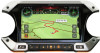
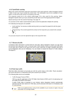
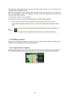
4.1.6 Speed limit warning Maps may contain information about the speed limits of the road segments. Alpine Navigation System is able to warn you if you exceed the current limit. This information may not be available for your region, or may not be fully correct for all roads on the map. The maximum speed set in the vehicle profile (page 73) is also used for this warning. Alpine Navigation System alerts you if you exceed the pre-set value even if the legal speed limit is higher. Speed warning can be fine-tuned in W arnings. See page 78. You can also set the relative speed tolerance above which the application initiates the warning. The following warning types are available: • Audio warning: You receive a verbal warning when you exceed the speed limit with the given percentage. • Visual warning: The current speed limit is shown on the map when you exceed it (for example ). You can also choose to see the speed limit sign on the map all the time. 4.1.7 Historical traffic If statistical traffic information is stored with the map data, Alpine Navigation System can take them into account when planning a route. In normal cases, these statistics help you avoid usual traffic jams on the given day of week in the given hour but in some cases like on public vacations that fall on normal weekdays, they can be misleading. You can enable or disable this feature in Traffic settings. See page 83. 4.1.8 Real-time traffic Real-time traffic information can provide you with the current status of the traffic. Route calculation can avoid road blocks or unexpected traffic jams caused by an accident. The following data sources are available: • Traffic Message Channel (TMC): TMC is a specific application of the FM Radio Data System (RDS) used for broadcasting realtime traffic and weather information. If public Traffic data is broadcast at your location, Alpine Navigation System automatically searches the FM radio stations for TMC data, and the decoded information is immediately used in route planning. TMC is not a global service. It may not be available in your country or region. Ask your Note! local dealer for coverage details. 65
-
 1
1 -
2
-
3
-
4
-
5
-
6
-
7
-
8
-
9
-
10
-
11
-
12
-
13
-
14
-
15
-
16
-
17
-
18
-
19
-
20
-
21
-
22
-
23
-
24
-
25
-
26
-
27
-
28
-
29
-
30
-
31
-
32
-
33
-
34
-
35
-
36
-
37
-
38
-
39
-
40
-
41
-
42
-
43
-
44
-
45
-
46
-
47
-
48
-
49
-
50
-
51
-
52
-
53
-
54
-
55
-
56
-
57
-
58
-
59
-
 60
60 -
 61
61 -
 62
62 -
 63
63 -
 64
64 -
 65
65 -
 66
66 -
 67
67 -
 68
68 -
 69
69 -
 70
70 -
71
-
72
-
73
-
74
-
75
-
76
-
77
-
78
-
79
-
80
-
81
-
82
-
83
-
84
-
85
-
86
-
87
-
88
-
89
-
90
-
91
-
92
-
93
-
94
-
95
-
96
-
97
-
98
-
99
-
100
-
101
-
102
-
103
-
104
-
105
-
106
-
107
-
108
-
109
-
110
-
111
-
112
-
113
-
114
-
115
-
116
-
117
-
118
-
119
-
120
-
121
-
122
-
123
-
124
-
125
-
126
-
127
-
128
-
129
-
130
-
131
-
132
-
133
-
134
-
135
-
136
-
137
-
138
-
139
-
140
-
141
-
142
-
143
-
144
-
145
-
146
-
147
-
148
-
149
-
150
-
151
-
152
-
153
-
154
-
155
-
156
-
157
-
158
-
159
-
160
-
161
-
162
-
163
-
164
-
165
-
166
-
167
-
168
-
169
-
170
-
171
-
172
-
173
-
174
-
175
-
176
-
177
-
178
-
179
-
180
-
181
-
182
-
183
-
184
-
185
-
186
-
187
-
188
-
189
-
190
-
191
-
192
-
193
-
194
-
195
-
196
-
197
-
198
-
199
-
200
-
201
-
202
-
203
-
204
-
205
-
206
-
207
-
208
-
209
-
210
-
211
-
212
-
213
-
214
-
215
-
216
-
217
-
218
-
219
-
220
-
221
-
222
-
223
-
224
-
225
-
226
-
227
-
228
-
229
-
230
-
231
-
232
-
233
-
234
-
235
-
236
-
237
-
238
-
239
-
240
-
241
-
242
-
243
-
244
-
245
-
246
-
247
-
248
-
249
-
250
-
251
-
252
-
253
-
254
-
255
-
256
-
257
-
258
-
259
-
260
-
261
-
262
-
263
-
264
-
265
-
266
-
267
-
268
-
269
-
270
-
271
-
272
-
273
-
274
-
275
-
276
-
277
-
278
-
279
-
280
 |
 |
