Garmin GPSMAP 2206 GPSMAP 2206/2210 Owner's Manual - Page 68
Position Format, Depth, Map Datum, WGS 84, Temperature, Distance, Speed, and Elevation, Pressure - s 6 4 inch
 |
UPC - 753759053024
View all Garmin GPSMAP 2206 manuals
Add to My Manuals
Save this manual to your list of manuals |
Page 68 highlights
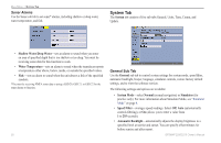
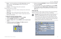
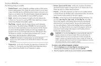
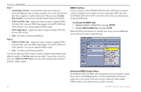
MAIN MENU > SYSTEM TAB The following settings are available: • Position Format-used to change the coordinate system in which a given location reading appears. Only change the position format if you are using a map or chart that specifies a different position format or you want to use a format you are familiar with. The default format is latitude and longitude in degrees, minutes, and thousandths of a minute (hddd°mm.mmm'). • Depth-select the units of measure for depth in Feet (ft), Fathoms (fa), or Meters (m). You must be receiving NMEA Sonar depth data or using a Garmin Sonar Module for the depth to appear. • Map Datum-manually select the datum reference used to determine a given location. The default setting is WGS 84. The unit automatically selects the best datum depending on your chosen position format. Datums are used to describe geographic locations for surveying, mapping, and navigation and are not actual maps built in the unit. Although more than 100 datums are available, you should change the datum only if you are using a map or chart that specifies a different datum. WARNING: Selecting the wrong map datum can result in substantial position errors. When in doubt, use the default WGS 84 datum for best overall performance. • Temperature-set the units of measure for temperature in Fahrenheit (°F) or Celsius (°C). You must be receiving NMEA Sonar temperature data or using a Garmin Sonar Module for the Temperature to appear. • Distance, Speed, and Elevation-set the units of measure for distance, speed and elevation readouts in Nautical (nm, kt, ft), Nautical (nm, kt, m), Statute (mi, mh, ft), or Metric (km, kh, m) terms. • Pressure-set the units of measure you want to use for weather readouts in Inches Mercury (in), Millibars (mb), or Hectopascals (hPa). You must be using a Garmin weather product for this data to appear. • Heading-set the reference used in calculating heading information. You can select Auto Mag Var, True, Grid, and User Mag Var. Auto Mag Var provides magnetic north heading references that are automatically determined from your present location. True provides headings based on a true north reference. Grid provides headings based on a grid north reference. User Mag Var allows you to specify the magnetic variation at your present location and provides magnetic north heading references based on the variation you enter. WARNING: If you select User Mag Var, you must periodically update the magnetic variation as your location changes. When using this setting, the GPSMAP 2206/2210 unit does not automatically calculate and update the magnetic variation at your present location. Failure to update this setting can result in substantial differences between the information displayed on your unit and external references, such as a magnetic compass. To enter a user-defined magnetic variation: 1. With the Heading field set to User Mag Var, highlight the heading reference field (immediately to the right), and press ENTER. 2. Enter the magnetic variation at your current location, and press ENTER. 60 GPSMAP 2206/2210 Owner's Manual
-
 1
1 -
2
-
3
-
4
-
5
-
6
-
7
-
8
-
9
-
10
-
11
-
12
-
13
-
14
-
15
-
16
-
17
-
18
-
19
-
20
-
21
-
22
-
23
-
24
-
25
-
26
-
27
-
28
-
29
-
30
-
31
-
32
-
33
-
34
-
35
-
36
-
37
-
38
-
39
-
40
-
41
-
42
-
43
-
44
-
45
-
46
-
47
-
48
-
49
-
50
-
51
-
52
-
53
-
54
-
55
-
56
-
57
-
58
-
59
-
60
-
61
-
62
-
 63
63 -
 64
64 -
 65
65 -
 66
66 -
 67
67 -
 68
68 -
 69
69 -
 70
70 -
 71
71 -
 72
72 -
 73
73 -
74
-
75
-
76
-
77
-
78
-
79
-
80
-
81
-
82
-
83
-
84
-
85
-
86
-
87
-
88
-
89
-
90
-
91
-
92
-
93
-
94
-
95
-
96
-
97
-
98
-
99
-
100
-
101
-
102
-
103
-
104
-
105
-
106
 |
 |
