Garmin GPSMAP 2206 GPSMAP 2206/2210 Owner's Manual - Page 92
What is WAAS/EGNOS?, WAAS Capability
 |
UPC - 753759053024
View all Garmin GPSMAP 2206 manuals
Add to My Manuals
Save this manual to your list of manuals |
Page 92 highlights
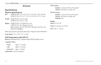
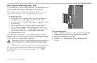
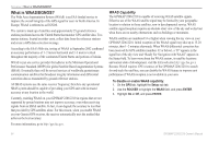
APPENDIX > WHAT IS WAAS/EGNOS? What is WAAS/EGNOS? The Wide Area Augmentation System (WAAS) is an FAA-funded service to improve the overall integrity of the GPS signal for users in North America. In Europe, WAAS is referred to as EGNOS. The system is made up of satellites and approximately 25 ground reference stations positioned across the United States that monitor GPS satellite data. Two master stations, located on either coast, collect data from the reference stations and create a GPS data correction message. According to the FAA's Web site, testing of WAAS in September 2002 confirmed an accuracy performance of 1-2 meters horizontal and 2-3 meters vertical throughout the majority of the continental United States and portions of Alaska. WAAS is just one service provider that adheres to the Minimum Operational Performance Standard (MOPS) for global Satellite Based Augmentation Systems (SBAS). Eventually there will be several services of worldwide geostationary communication satellites that broadcast integrity information and differential correction data as transmitted by ground reference stations. All SBAS systems use the same receiver frequency; therefore any operational SBAS system should be capable of providing your GPS unit with increased accuracy at any location in the world. Currently, enabling WAAS on your GPSMAP 2206/2210 in regions that are not supported by ground stations may not improve accuracy, even when receiving signals from an SBAS satellite. In fact, it can degrade the accuracy to less than that provided by GPS satellites alone. For this reason, when you enable WAAS on your Garmin GPS receiver, the receiver automatically uses the method that achieves the best accuracy. For more information, go to http://gps.faa.gov. WAAS Capability The GPSMAP 2206/2210 is capable of receiving WAAS satellite signals. Effective use of the WAAS satellite signal may be limited by your geographic location in relation to those satellites, now in developmental service. WAAS satellite signal reception requires an absolute clear view of the sky and works best when there are no nearby obstructions such as buildings or mountains. WAAS satellites are numbered 33 or higher when viewing the sky view on your GPSMAP 2206/2210. Initial reception of the WAAS signal may take up to 15-20 minutes, then 1-2 minutes afterwards. When WAAS differential correction has been received for GPS satellites (numbers 32 or below), a "D" appears in the signal bar of the sky view and "Ready For Navigation with WAAS" appears in the Status field. To learn more about the WAAS system, its satellite locations and current state of development, visit the FAA web site (http://gps.faa.gov). Because WAAS requires CPU resources of the GPSMAP 2206/2210 to search for and track the satellites, you can disable the WAAS feature to improve unit performance if WAAS reception is not available in your area. To disable or enable WAAS capability: 1. On the GPS tab, highlight the Setup sub tab. 2. Use the ROCKER to highlight the WAAS field, and press ENTER. 3. Highlight On or Off, and press ENTER. 84 GPSMAP 2206/2210 Owner's Manual
-
 1
1 -
2
-
3
-
4
-
5
-
6
-
7
-
8
-
9
-
10
-
11
-
12
-
13
-
14
-
15
-
16
-
17
-
18
-
19
-
20
-
21
-
22
-
23
-
24
-
25
-
26
-
27
-
28
-
29
-
30
-
31
-
32
-
33
-
34
-
35
-
36
-
37
-
38
-
39
-
40
-
41
-
42
-
43
-
44
-
45
-
46
-
47
-
48
-
49
-
50
-
51
-
52
-
53
-
54
-
55
-
56
-
57
-
58
-
59
-
60
-
61
-
62
-
63
-
64
-
65
-
66
-
67
-
68
-
69
-
70
-
71
-
72
-
73
-
74
-
75
-
76
-
77
-
78
-
79
-
80
-
81
-
82
-
83
-
84
-
85
-
86
-
 87
87 -
 88
88 -
 89
89 -
 90
90 -
 91
91 -
 92
92 -
 93
93 -
 94
94 -
 95
95 -
 96
96 -
 97
97 -
98
-
99
-
100
-
101
-
102
-
103
-
104
-
105
-
106
 |
 |
