Garmin GPSMAP 2206 GPSMAP 2206/2210 Owner's Manual - Page 8
Warning, Caution, Map Data Information - marine gps
 |
UPC - 753759053024
View all Garmin GPSMAP 2206 manuals
Add to My Manuals
Save this manual to your list of manuals |
Page 8 highlights
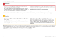
INTRODUCTION > WARNING AND CAUTION Warning Failure to avoid the following potentially hazardous situations could result in an accident or collision resulting in death or serious injury. When navigating, carefully compare information displayed on the GPSMAP 2206/2210 to all available navigation sources, including information from visual sightings, and maps. For safety, always resolve any discrepancies or questions before continuing navigation. Use the electronic chart in the GPSMAP 2206/2210 only to facilitate, not to replace, the use of authorized government charts. Official government charts and notices to mariners contain all information needed to navigate safely. Use terrain and obstacle data only as an aid to situational awareness. WARNING: This product, its packaging, and its components contain chemicals known to the State of California to cause cancer, birth defects, or reproductive harm. This Notice is being provided in accordance with California's Proposition 65. If you have any questions or would like additional information, please refer to our Web site at http://www.garmin.com/prop65. Caution Failure to avoid the following potentially hazardous situations may result in injury or property damage. Use the GPSMAP 2206/2210 only as a navigational aid. Do not attempt to use the GPSMAP 2206/2210 for any purpose requiring precise measurement of direction, distance, location, or topography. The Global Positioning System (GPS) is operated by the United States government, which is solely responsible for its accuracy and maintenance. The government's system is subject to changes which could affect the accuracy and performance of all GPS equipment, including the GPSMAP 2206/2210. Although the GPSMAP 2206/2210 is a precision navigation device, any navigation device can be misused or misinterpreted and, therefore, become unsafe. Map Data Information: One of the goals of Garmin is to provide customers with the most complete and accurate cartography that is available to us at a reasonable cost. We use a combination of governmental and private data sources, which we identify in product literature and copyright messages displayed to the consumer. Virtually all data sources contain inaccurate or incomplete data to some extent. In some countries, complete and accurate digital data is either not available or is prohibitively expensive. NOTICE: This Category II radiocommunication device complies with Industry Canada Standard RSS-310. iv GPSMAP 2206/2210 Owner's Manual
-
 1
1 -
2
-
 3
3 -
 4
4 -
 5
5 -
 6
6 -
 7
7 -
 8
8 -
 9
9 -
 10
10 -
 11
11 -
 12
12 -
 13
13 -
14
-
15
-
16
-
17
-
18
-
19
-
20
-
21
-
22
-
23
-
24
-
25
-
26
-
27
-
28
-
29
-
30
-
31
-
32
-
33
-
34
-
35
-
36
-
37
-
38
-
39
-
40
-
41
-
42
-
43
-
44
-
45
-
46
-
47
-
48
-
49
-
50
-
51
-
52
-
53
-
54
-
55
-
56
-
57
-
58
-
59
-
60
-
61
-
62
-
63
-
64
-
65
-
66
-
67
-
68
-
69
-
70
-
71
-
72
-
73
-
74
-
75
-
76
-
77
-
78
-
79
-
80
-
81
-
82
-
83
-
84
-
85
-
86
-
87
-
88
-
89
-
90
-
91
-
92
-
93
-
94
-
95
-
96
-
97
-
98
-
99
-
100
-
101
-
102
-
103
-
104
-
105
-
106
 |
 |