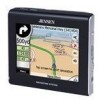
Jensen NVX225 User Manual - Page 22
GPS connection indicator, 3.3 GPS data quality indicator
 |
UPC - 044476040818
View all Jensen NVX225 manuals
Add to My Manuals
Save this manual to your list of manuals |
Page 22 highlights
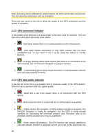
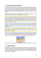
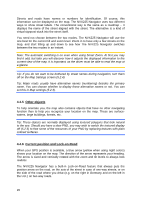
Note: Accuracy can be affected by several factors the GPS cannot take into account. Use this accuracy information only as estimation. There are two icons on the left to show the status of the GPS connection and the quality of reception. 4.3.2 GPS connection indicator In the middle to the left there is a lamp similar to the ones used for switches. This one has more colors and represents more values: • - Dark lamp means there is no communication on the selected port, • - Red lamp means connection to any GPS receiver has not been established yet, so you need to set it up by using the Detect or Config. Buttons, • - A slowly blinking yellow lamp means that there is no connection to the GPS receiver, but The NVX225 Navigator is trying to connect, • - A fast blinking green lamp means that there is communication with the GPS and data is being received. 4.3.3 GPS data quality indicator In the top left corner there is a satellite dish to show the quality of the GPS position. Different colors represent different signal quality: • - Black with a red cross means there is no connection with the GPS device, • - Red means the GPS is connected but no GPS position is available, • - Yellow means 2D reception. A GPS position has been acquired, The NVX225 Navigator is ready for navigation, but the GPS is using enough satellites for calculating the horizontal position only. Elevation data is not provided, and the position error may be significant. • - Green means 3D reception. The GPS receiver has enough satellites to calculate altitude. Position is generally correct (yet it can still be inaccurate due 22
-
 1
1 -
2
-
3
-
4
-
5
-
6
-
7
-
8
-
9
-
10
-
11
-
12
-
13
-
14
-
15
-
16
-
 17
17 -
 18
18 -
 19
19 -
 20
20 -
 21
21 -
 22
22 -
 23
23 -
 24
24 -
 25
25 -
 26
26 -
 27
27 -
28
-
29
-
30
-
31
-
32
-
33
-
34
-
35
-
36
-
37
-
38
-
39
-
40
-
41
-
42
-
43
-
44
-
45
-
46
-
47
-
48
-
49
-
50
-
51
-
52
-
53
-
54
-
55
-
56
-
57
-
58
-
59
-
60
-
61
-
62
-
63
-
64
-
65
-
66
-
67
-
68
-
69
-
70
-
71
-
72
-
73
-
74
-
75
-
76
-
77
-
78
-
79
-
80
-
81
-
82
-
83
-
84
-
85
-
86
-
87
-
88
-
89
 |
 |
