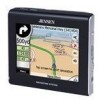
Jensen NVX225 User Manual - Page 27
Selected map point, also known as the Cursor, 4.8 Marked map points Pin
 |
UPC - 044476040818
View all Jensen NVX225 manuals
Add to My Manuals
Save this manual to your list of manuals |
Page 27 highlights
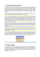
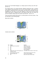
The location received from the GPS receiver is shown as a blue dot on the map. This can help you locate your position if the GPS accuracy is poor, and the Lock-on-Road system puts you on the wrong street. It is also the location saved in the track log (4.7.2.6). Note: the Lock-on-Road feature can be turned off in advanced settings (5.6.4.4) for pedestrian use. When switched off, the arrow is displayed where the blue dot would be with active Lock-on-Road. When the GPS position is lost, the arrow turns grey and jumps to the last known position, disabling Lock-on-Road (the last position before losing the reception is usually inaccurate, and there is a chance that Lock-on-Road may choose the wrong street). 4.4.7 Selected map point, also known as the Cursor If you tap the map somewhere or select a specific item in Find, it will become the selected point on the map, marked with a small red dot and permanently radiating red circles to make it conspicuous at all zoom levels, even when it is in the background of a 3D map view. You can use this point as starting point, via point, or destination of your route, you can search for a POI near to it, mark it with a drawingpin, or save it as a POI. The cursor, when visible, is also the reference point for map scaling. Note: When your GPS position is available, and Lock-to-Position is active, the cursor is always the current GPS position. When you select another point by tapping the map, or using Find, the new Cursor is shown on the display, Lock-to-Position becomes disabled, and the Lock button appears on the screen. Now the Cursor is the newly selected point. As soon as you tap the Lock button, or after the given timeout The NVX225 Navigator restores Lock-to-Position (5.6.3.3), and the Cursor jumps back to the current GPS position. 4.4.8 Marked map points (Pin) The Cursor can be marked with a pin. Pins are shown as being stuck in the map. A pin is visible at all zoom levels and remains in its position until you unpin it, or delete all pins in advanced settings (5.6.5.3). The NVX225 Navigator automatically selects the color of the pin. Different colors help you identify a pin in the History list (6.3.2) later. There they are shown together with their address and GPS coordinates. Tip: A quick way to tell the coordinates of a location you found on the map is to pin it, and then look for the coordinates in the History list (6.3.2). This way you also save the coordinates with the pin for later reference. If you do not need the coordinates later, just select the point and start Find Coordinates (6.3.3). 27
-
 1
1 -
2
-
3
-
4
-
5
-
6
-
7
-
8
-
9
-
10
-
11
-
12
-
13
-
14
-
15
-
16
-
17
-
18
-
19
-
20
-
21
-
 22
22 -
 23
23 -
 24
24 -
 25
25 -
 26
26 -
 27
27 -
 28
28 -
 29
29 -
 30
30 -
 31
31 -
 32
32 -
33
-
34
-
35
-
36
-
37
-
38
-
39
-
40
-
41
-
42
-
43
-
44
-
45
-
46
-
47
-
48
-
49
-
50
-
51
-
52
-
53
-
54
-
55
-
56
-
57
-
58
-
59
-
60
-
61
-
62
-
63
-
64
-
65
-
66
-
67
-
68
-
69
-
70
-
71
-
72
-
73
-
74
-
75
-
76
-
77
-
78
-
79
-
80
-
81
-
82
-
83
-
84
-
85
-
86
-
87
-
88
-
89
 |
 |
