Jensen NVX225 User Manual - Page 29
Screens with map
 |
UPC - 044476040818
View all Jensen NVX225 manuals
Add to My Manuals
Save this manual to your list of manuals |
Page 29 highlights
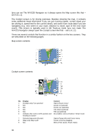
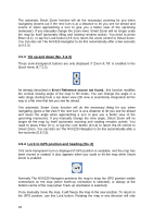
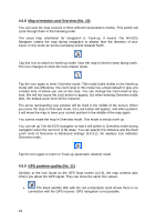
4.4.10.2 Animated turn guidance Animated arrows represent all route events other than the above-mentioned special points. These arrows show the direction in which you need to continue your journey. 4.4.10.3 The active leg of the route The active leg is the section of the route you are currently driving. If you have not added any via points, the whole route will be the active leg. When via points are present, the active leg is the part leading from your location to the next via point. The active section is displayed in light green when the sun is up, and in red during the night. In both cases it is the most conspicuous part of the map even when in the background of a 3D map view. The line of the route is displayed on the driving side of the road for two-way and on the axis in case of one-way streets. When the map is zoomed in and the line is wide enough, small arrows show the direction of the route. This can be useful if you preview the route before starting the journey or when entering a complex junction. 4.4.10.4 Inactive legs of the route Future sections of a route are inactive. They are also shown on the map with the same color but a darker tint than the active one. An inactive route section becomes active as soon as you reach its starting via point. 4.4.10.5 Roads in the route excluded by your preferences Although you can choose whether to include or avoid some road types in Route parameter settings (5.4.4), sometimes they are impossible to avoid near the starting point, via points or the destination. If so, The NVX225 Navigator will display those segments of the route with an alternate color. They are shown in red with daylight colors, and yellow with the night color scheme, both in active and inactive legs of the route. 4.5 Screens with map Having explained the contents of the map, the description of the other parts of the map screens follows. There is two map screens: the Map screen and the Cockpit screen. The way they show the map is the same but their look and controls are optimized for different purposes. The Map screen is to be used mainly without a GPS, to browse the map, create user POI items, or to plan your route based on map points. The Map screen is designed to give you the maximum map area. This screen is usually used in 2D North-up mode 29
-
 1
1 -
2
-
3
-
4
-
5
-
6
-
7
-
8
-
9
-
10
-
11
-
12
-
13
-
14
-
15
-
16
-
17
-
18
-
19
-
20
-
21
-
22
-
23
-
 24
24 -
 25
25 -
 26
26 -
 27
27 -
 28
28 -
 29
29 -
 30
30 -
 31
31 -
 32
32 -
 33
33 -
 34
34 -
35
-
36
-
37
-
38
-
39
-
40
-
41
-
42
-
43
-
44
-
45
-
46
-
47
-
48
-
49
-
50
-
51
-
52
-
53
-
54
-
55
-
56
-
57
-
58
-
59
-
60
-
61
-
62
-
63
-
64
-
65
-
66
-
67
-
68
-
69
-
70
-
71
-
72
-
73
-
74
-
75
-
76
-
77
-
78
-
79
-
80
-
81
-
82
-
83
-
84
-
85
-
86
-
87
-
88
-
89
 |
 |