Jensen NVX225 User Manual - Page 41
Warning icons
 |
UPC - 044476040818
View all Jensen NVX225 manuals
Add to My Manuals
Save this manual to your list of manuals |
Page 41 highlights
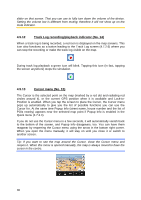
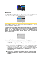
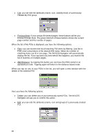
segments of the route. The calculation cannot take into account traffic jams and other possible delays. If via points exist, tap and tap again any of the fields to see the estimated arrival at the first, second, etc. via point. 4.6.1.6 Destination / Via point This field shows the exact address (or its coordinates if the address is not available) of the final destination. If via points exist, tap and tap again any of the fields to see the address or coordinates of the first, second, etc. via point. 4.6.2 Warning icons The following 5 squares are normally grey. Some of them turn red and show a graphical symbol in case warning(s) are attached to the planned route. These are warnings, so icons always show information for the whole route, even if the data fields display values from your current position to a via point only. Click on any of the icons to show its description. A few samples of the available icons: • - This icon shows that you need to pay toll on the recommended route. • - This icon shows that the route contains motorways. Tap the icon to see the total length of the motorways in the recommended route. • - This icon shows that toll roads are included in the recommended route. • - This icon shows that you need to board a ferry along the recommended route. • - This icon shows that you need to pay for the ferry. • - This icon is displayed when The NVX225 Navigator could not plan a route with all your road type preferences respected. Sometimes it is impossible to find a suitable route near the start or the destination. 41
-
 1
1 -
2
-
3
-
4
-
5
-
6
-
7
-
8
-
9
-
10
-
11
-
12
-
13
-
14
-
15
-
16
-
17
-
18
-
19
-
20
-
21
-
22
-
23
-
24
-
25
-
26
-
27
-
28
-
29
-
30
-
31
-
32
-
33
-
34
-
35
-
 36
36 -
 37
37 -
 38
38 -
 39
39 -
 40
40 -
 41
41 -
 42
42 -
 43
43 -
 44
44 -
 45
45 -
 46
46 -
47
-
48
-
49
-
50
-
51
-
52
-
53
-
54
-
55
-
56
-
57
-
58
-
59
-
60
-
61
-
62
-
63
-
64
-
65
-
66
-
67
-
68
-
69
-
70
-
71
-
72
-
73
-
74
-
75
-
76
-
77
-
78
-
79
-
80
-
81
-
82
-
83
-
84
-
85
-
86
-
87
-
88
-
89
 |
 |
