Garmin GPSMAP 67 Owners Manual - Page 10
Adjusting the Backlight, Acquiring Satellite Signals, GPS and Other Satellite Systems
 |
View all Garmin GPSMAP 67 manuals
Add to My Manuals
Save this manual to your list of manuals |
Page 10 highlights
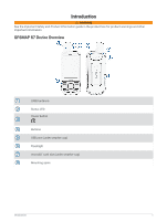
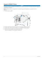
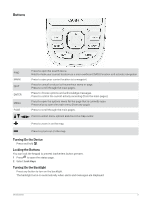
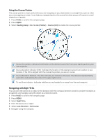
Adjusting the Backlight 1 Press to open the status page. 2 Use and to adjust the brightness. NOTE: To maximize battery life, the screen turns off automatically when the backlight times out. You can select Setup > Display to customize the backlight and display settings. Acquiring Satellite Signals It may take 30 to 60 seconds to acquire satellite signals. 1 Go outdoors to an open area. 2 If necessary, turn on the device. 3 Wait while the device searches for satellites. flashes while the device determines your GNSS location. in the status bar shows the satellite signal strength. When the device acquires satellite signals, it automatically starts recording your path as an activity. GPS and Other Satellite Systems Using GPS and another satellite system together offers increased performance in challenging environments and faster position acquisition than using GPS only. However, using multiple systems can reduce battery life more quickly than using GPS only. Your device can use these Global Navigation Satellite Systems (GNSS). Multi-band systems use multiple frequency bands and allow for more consistent track logs, improved positioning, improved multi-path errors, and fewer atmospheric errors when using the device in challenging environments. NOTE: You can view satellite locations and available satellite systems on the satellite page (Satellite Page, page 33). GPS: A satellite constellation built by the United States. GPS multi-band: A satellite constellation built by the United States, using the enhanced L5 signal. GLONASS: A satellite constellation built by Russia. GALILEO: A satellite constellation built by the European Space Agency. GALILEO multi-band: A satellite constellation built by the European Space Agency, using the enhanced L5 signal. QZSS multi-band: A satellite constellation built by Japan, using the enhanced L5 signal. IRNSS (NavIC): A satellite constellation built by India, using the enhanced L5 signal. Using the Main Pages The information needed to operate this device is found on the main menu, map, compass, and trip computer pages. Press PAGE or QUIT to scroll through the main pages. The page displayed in the middle opens automatically. Opening the Main Menu The main menu gives you access to tools and setup screens for waypoints, activities, routes, and more (Main Menu Tools, page 25, Setup Menu, page 36). From any page, press MENU twice. Map represents your location on the map. As you travel, moves and displays your path. Depending on your zoom level, waypoint names and symbols may appear on the map. You can zoom in on the map to see more detail. When you are navigating to a destination, your route is marked with a colored line on the map. 4 Using the Main Pages
-
 1
1 -
2
-
3
-
4
-
 5
5 -
 6
6 -
 7
7 -
 8
8 -
 9
9 -
 10
10 -
 11
11 -
 12
12 -
 13
13 -
 14
14 -
 15
15 -
16
-
17
-
18
-
19
-
20
-
21
-
22
-
23
-
24
-
25
-
26
-
27
-
28
-
29
-
30
-
31
-
32
-
33
-
34
-
35
-
36
-
37
-
38
-
39
-
40
-
41
-
42
-
43
-
44
-
45
-
46
-
47
-
48
-
49
-
50
-
51
-
52
-
53
-
54
-
55
-
56
-
57
-
58
-
59
-
60
 |
 |
