Sony DEV-50 Digital Recording Binoculars Handbook - Page 79
About the memory card, On triangulating errors, On the restriction of use of GPS
 |
View all Sony DEV-50 manuals
Add to My Manuals
Save this manual to your list of manuals |
Page 79 highlights
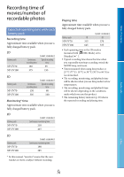
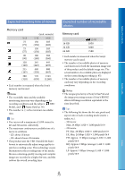
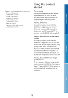
Determining a location is called Error caused by the position of GPS satellites Table of Contents "triangulating." A GPS receiver can determine the location's latitude and longitude by receiving signals from 3 or more satellites. As the positions of GPS satellites vary constantly, it may take longer to determine the location or the receiver may not be able to determine the location at all, depending on the location and time you use this product. "GPS" is a system for determining geographic location by triangulating radio signals from GPS satellites. Avoid using this feature in places where radio signals are blocked or reflected, such as a shadowy place surrounded by buildings or trees, etc. Use this feature in open sky environments. You may not be able to record location information at locations or in situations where radio signals from the GPS satellites do not reach this product as follows. In tunnels, indoors or under the shade of This product automatically triangulates your current location when this product receives radio signals from 3 or more GPS satellites. The triangulating error allowed by the GPS satellites is about 10 m (33 feet). Depending on the environment of the location, the triangulating error can be greater. In this case, your actual location may not match the location on the GPS information. Meanwhile, the GPS satellites are controlled by the United States Department of Defense, and the degree of accuracy may be changed intentionally. Error during the triangulating process This product acquires location information periodically during triangulating. There is a slight time difference between when the location information is acquired and when the location information is recorded on an image, therefore, the actual recording location may not match exactly the location on the map based on the GPS information. Menu Lists buildings. On the restriction of use of GPS Between tall buildings or at narrow streets surrounded by buildings. In underground locations, locations Use GPS in accordance with the regulations of the situation, the countries/regions of use. surrounded by dense trees, under an elevated On the geographic coordinate system bridge, or in locations where magnetic fields are generated, such as near high voltage cables. The "WGS-84" geographic coordinate system is used. Near devices that generate radio signals of the same frequency band as this product: near 1.5 About the memory card GHz band mobile telephones, etc. When you upload to or share on the web images recorded with [GPS Setting] set to [On], location information may unintentionally be made known to others. If you want to avoid that situation, set [GPS Setting] to [Off] (p. 62). A memory card formatted by a computer (Windows OS/Mac OS) does not have guaranteed compatibility with this product. Data read/write speed may vary depending on the combination of the memory card and memory card compliant product you use. Index On triangulating errors If you move to another location right after turning the power switch to ON, it may take a longer time for this product to start triangulating, compared to when you stay in the same place. Damaged or lost data may occur in the following cases (the data will not be compensated for): If you eject the memory card, or turn off this product while this product is reading or writing image files on the memory card (while the access lamp is lit or flashing) If you use the memory card near magnets or GB magnetic fields 79
-
 1
1 -
2
-
3
-
4
-
5
-
6
-
7
-
8
-
9
-
10
-
11
-
12
-
13
-
14
-
15
-
16
-
17
-
18
-
19
-
20
-
21
-
22
-
23
-
24
-
25
-
26
-
27
-
28
-
29
-
30
-
31
-
32
-
33
-
34
-
35
-
36
-
37
-
38
-
39
-
40
-
41
-
42
-
43
-
44
-
45
-
46
-
47
-
48
-
49
-
50
-
51
-
52
-
53
-
54
-
55
-
56
-
57
-
58
-
59
-
60
-
61
-
62
-
63
-
64
-
65
-
66
-
67
-
68
-
69
-
70
-
71
-
72
-
73
-
 74
74 -
 75
75 -
 76
76 -
 77
77 -
 78
78 -
 79
79 -
 80
80 -
 81
81 -
 82
82 -
 83
83 -
 84
84 -
85
-
86
-
87
-
88
-
89
-
90
 |
 |