Garmin GPSMAP 4210 Owner's Manual - Page 24
Detailed Road and POI Data, Using Automatic Guidance, Road
 |
View all Garmin GPSMAP 4210 manuals
Add to My Manuals
Save this manual to your list of manuals |
Page 24 highlights
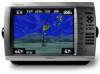
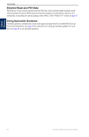
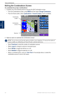
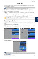
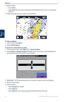
Using Charts Detailed Road and POI Data BlueChart g2 Vision contains detailed road and POI data, which includes highly detailed coastal roads and points of interest (POIs) such as restaurants, lodging, local attractions, and more. For instructions on searching for and navigating to these POIs, see the "Where To?" section on page 23. Using Automatic Guidance Automatic guidance automatically creates and suggests passage based on available BlueChart g2 Vision chart information. See page 39 for instructions on setting up automatic guidance for your boat. See page 28 to use automatic guidance. Using Charts 20 GPSMAP 4000 Series Owner's Manual
-
 1
1 -
2
-
3
-
4
-
5
-
6
-
7
-
8
-
9
-
10
-
11
-
12
-
13
-
14
-
15
-
16
-
17
-
18
-
 19
19 -
 20
20 -
 21
21 -
 22
22 -
 23
23 -
 24
24 -
 25
25 -
 26
26 -
 27
27 -
 28
28 -
 29
29 -
30
-
31
-
32
-
33
-
34
-
35
-
36
-
37
-
38
-
39
-
40
-
41
-
42
-
43
-
44
-
45
-
46
-
47
-
48
-
49
-
50
-
51
-
52
-
53
-
54
-
55
-
56
-
57
-
58
-
59
-
60
-
61
-
62
-
63
-
64
-
65
-
66
-
67
-
68
-
69
-
70
-
71
-
72
-
73
-
74
-
75
-
76
-
77
-
78
-
79
-
80
-
81
-
82
-
83
-
84
 |
 |

20
GPSMAP 4000 Series Owner’s Manual
Using Charts
U
SING
C
HARTS
Detailed
Road and
POI Data
BlueChart g2 Vision contains detailed road and POI data, which includes highly detailed coastal
roads and points of interest (POIs) such as restaurants, lodging, local attractions, and more. For
instructions on searching for and navigating to these POIs, see the “Where To?” section on
page 23
.
Using Automatic Guidance
Automatic guidance automatically creates and suggests passage based on available BlueChart g2
Vision chart information. See
page 39
for instructions on setting up automatic guidance for your
boat. See
page 28
to use automatic guidance.