Garmin GPSMAP 4210 Owner's Manual - Page 34
Viewing Celestial Information, Viewing User Data, User Data - software
 |
View all Garmin GPSMAP 4210 manuals
Add to My Manuals
Save this manual to your list of manuals |
Page 34 highlights
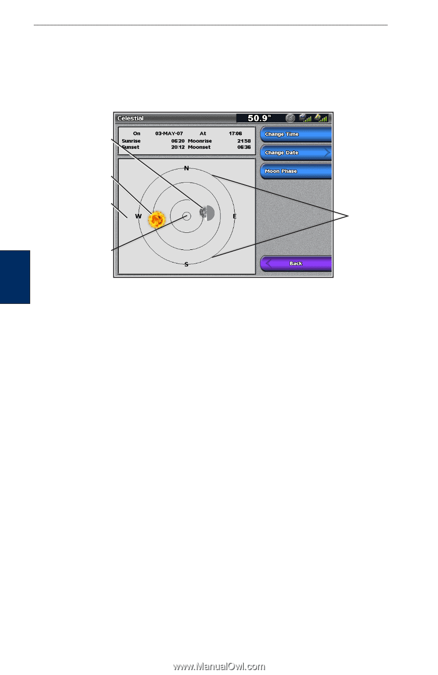
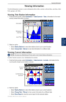
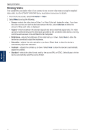
Viewing Information Viewing Celestial Information Use the Celestial screen to view celestial data for sunrise, sunset, moonrise, moonset, moon phase, and approximate sky view location of the sun and moon. By default, the chartplotter displays celestial information for the current date and time. From the Home screen, select Information > Tides/Currents > Celestial. Moon position Sun position Sky view window Overhead Horizon Viewing Information To change the date or time, or to view the moon phase: 1. From the Home screen, select Information > Tides/Currents > Celestial. 2. Select an option: • Select Change Date > Manual to view information for a different date. • Select Change Time to view information for a specified time on that date. • Select Moon Phase to view the moon phase at the specified date and time. Viewing User Data 1. From the Home screen, select Information > User Data. 2. Select an option: • Select Waypoints to view a list of all saved waypoints (page 25). • Select Routes to view a list of saved routes (page 27). • Select Tracks to view and manage tracks (page 13). • Select Data Transfer to transfer waypoints, routes, and tracks to and from an SD card or network. • Select Clear User Data to erase all user waypoints, routes, and tracks. To copy or merge MapSource® data to your chartplotter: 1. Insert an SD card into your chartplotter to allow it to place a file on the SD card. This file provides information to MapSource to format its data. This must be done only the first time you copy or merge MapSource data to your chartplotter from a specific SD card. 2. Check your MapSource version on the computer by clicking Help > About MapSource. If the version is older than 6.12.2, update to the most current version by clicking Help > Check for Software Updates, or check the Garmin Web site at www.garmin.com. 3. Insert the SD card into an SD card reader attached to the computer. 4. From within MapSource, click Transfer > Send to Device. 30 GPSMAP 4000 Series Owner's Manual
-
 1
1 -
2
-
3
-
4
-
5
-
6
-
7
-
8
-
9
-
10
-
11
-
12
-
13
-
14
-
15
-
16
-
17
-
18
-
19
-
20
-
21
-
22
-
23
-
24
-
25
-
26
-
27
-
28
-
 29
29 -
 30
30 -
 31
31 -
 32
32 -
 33
33 -
 34
34 -
 35
35 -
 36
36 -
 37
37 -
 38
38 -
 39
39 -
40
-
41
-
42
-
43
-
44
-
45
-
46
-
47
-
48
-
49
-
50
-
51
-
52
-
53
-
54
-
55
-
56
-
57
-
58
-
59
-
60
-
61
-
62
-
63
-
64
-
65
-
66
-
67
-
68
-
69
-
70
-
71
-
72
-
73
-
74
-
75
-
76
-
77
-
78
-
79
-
80
-
81
-
82
-
83
-
84
 |
 |