Garmin GPSMAP 4210 Owner's Manual - Page 68
Viewing Buoy Reports
 |
View all Garmin GPSMAP 4210 manuals
Add to My Manuals
Save this manual to your list of manuals |
Page 68 highlights
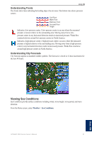
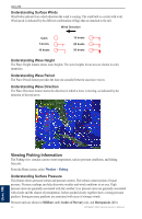
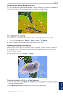
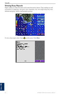
Using XM Viewing Buoy Reports Report readings are taken from buoys and coastal observation stations. These readings are used to determine air temperature, dew point, water temperature, tide, wave height and period, wind direction and speed, visibility, and barometric pressure. To view a buoy report, select a buoy on the screen. Select Buoy. Using XM 64 GPSMAP 4000 Series Owner's Manual
-
 1
1 -
2
-
3
-
4
-
5
-
6
-
7
-
8
-
9
-
10
-
11
-
12
-
13
-
14
-
15
-
16
-
17
-
18
-
19
-
20
-
21
-
22
-
23
-
24
-
25
-
26
-
27
-
28
-
29
-
30
-
31
-
32
-
33
-
34
-
35
-
36
-
37
-
38
-
39
-
40
-
41
-
42
-
43
-
44
-
45
-
46
-
47
-
48
-
49
-
50
-
51
-
52
-
53
-
54
-
55
-
56
-
57
-
58
-
59
-
60
-
61
-
62
-
 63
63 -
 64
64 -
 65
65 -
 66
66 -
 67
67 -
 68
68 -
 69
69 -
 70
70 -
 71
71 -
 72
72 -
 73
73 -
74
-
75
-
76
-
77
-
78
-
79
-
80
-
81
-
82
-
83
-
84
 |
 |

³4
GPSMAP 4000 Series Owner’s Manual
Using XM
U
SING
XM
Viewing
Buoy Reports
Report readings are taken from buoys and coastal observation stations. These readings are used
to determine air temperature, dew point, water temperature, tide, wave height and period, wind
direction and speed, visibility, and barometric pressure.
To view a buoy report, select a buoy
on the screen. Select
Buoy
.