Sony HDR-XR160 Handycam® Handbook - Page 112
Maintenance and precautions, About the AVCHD format, About GPS (HDR-CX360V/PJ30V/PJ50V), PJ50V
 |
UPC - 027242820081
View all Sony HDR-XR160 manuals
Add to My Manuals
Save this manual to your list of manuals |
Page 112 highlights
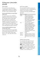
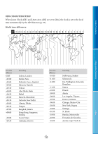
Maintenance and precautions Table of Contents Enjoy Useful Functions About the AVCHD format What is the AVCHD format? The AVCHD format is a high definition digital video camera format used to record a high definition (HD) signal using efficient data compression coding technology. The MPEG-4 AVC/H.264 format is adopted to compress video data, and the Dolby Digital or Linear PCM system is used to compress audio data. The MPEG-4 AVC/H.264 format is capable of compressing images at higher efficiency than that of the conventional image compressing format. As the AVCHD format uses a compression coding technology, the picture may be disturbed in scenes where picture, field angles or brightness, etc. change drastically, but this is not a malfunction. Recording and playback on your camcorder Based on the AVCHD format, your camcorder records with the high definition image quality (HD). In addition to high definition image quality (HD), your camcorder is capable of recording a standard definition (STD) signal in the conventional MPEG-2 format. Video signal*: MPEG-4 AVC/H.264 1920 1080/60i, 1440 1080/60i, 1920 1080/24p (HDR-CX360/CX360V/PJ30/ PJ30V/PJ50/PJ50V) Audio signal: Dolby Digital 2ch/5.1ch Recording media: Internal memory, memory card HDR-CX360/CX360V/PJ10/PJ30/PJ30V: Internal memory, memory card HDR-PJ50/PJ50V/XR160: Internal hard disk, memory card * Data recorded in AVCHD format other than the above mentioned cannot be played on your camcorder. About GPS (HDR-CX360V/PJ30V/ PJ50V) The GPS (Global Positioning System) is a system that calculates geographical location from highly accurate US space satellites. This system allows you to pinpoint your exact location on the earth. The GPS satellites are located in 6 orbits, 20,000 km above the earth. The GPS system consists of 24 or more GPS satellites. A GPS receiver receives radio signals from the satellites, and calculates the current location of the receiver based on the orbital information (almanac data) and travel time of the signals, etc. Determining a location is called "triangulating." A GPS receiver can determine the location's latitude and longitude by receiving signals from 3 or more satellites. As the positions of GPS satellites vary constantly, it may take longer to determine the location or the receiver may not be able to determine the location at all, depending on the location and time you use the camcorder. "GPS" is a system for determining geographic location by triangulating radio signals from GPS satellites. Avoid using the camcorder in places where radio signals are blocked or reflected, such as a shadowy place surrounded by buildings or trees, etc. Use the camcorder in open sky environments. You may not be able to record location information at locations or in situations where radio signals from the GPS satellites do not reach the camcorder as follows. US 112 Index
-
 1
1 -
2
-
3
-
4
-
5
-
6
-
7
-
8
-
9
-
10
-
11
-
12
-
13
-
14
-
15
-
16
-
17
-
18
-
19
-
20
-
21
-
22
-
23
-
24
-
25
-
26
-
27
-
28
-
29
-
30
-
31
-
32
-
33
-
34
-
35
-
36
-
37
-
38
-
39
-
40
-
41
-
42
-
43
-
44
-
45
-
46
-
47
-
48
-
49
-
50
-
51
-
52
-
53
-
54
-
55
-
56
-
57
-
58
-
59
-
60
-
61
-
62
-
63
-
64
-
65
-
66
-
67
-
68
-
69
-
70
-
71
-
72
-
73
-
74
-
75
-
76
-
77
-
78
-
79
-
80
-
81
-
82
-
83
-
84
-
85
-
86
-
87
-
88
-
89
-
90
-
91
-
92
-
93
-
94
-
95
-
96
-
97
-
98
-
99
-
100
-
101
-
102
-
103
-
104
-
105
-
106
-
 107
107 -
 108
108 -
 109
109 -
 110
110 -
 111
111 -
 112
112 -
 113
113 -
 114
114 -
 115
115 -
 116
116 -
 117
117 -
118
-
119
-
120
-
121
-
122
-
123
-
124
-
125
-
126
-
127
-
128
-
129
 |
 |