Garmin Geko 301 Owner's Manual - Page 26
Elevation
 |
UPC - 753759042073
View all Garmin Geko 301 manuals
Add to My Manuals
Save this manual to your list of manuals |
Page 26 highlights
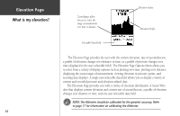
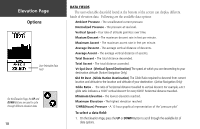
Elevation Page What is my elevation? 14 Zoom Ranges allow the user to select the range of measurement over time or distance Selectable Data Field Elevation Status Elevation Profile The Elevation Page provides the user with the current elevation, rate of ascent/descent, a profile of elevation changes over distance or time, or a profile of pressure changes over time (displayed in the user selectable field). The Elevation Page Options Menu allows you to select from a variety of display options such as plotting over time, plotting over distance, displaying the zoom ranges of measurement, viewing elevation or pressure points, and resetting data displays. A single user-selectable data field allows you to display a variety of current and recorded pressure and elevation-related data. The Elevation Page provides you with a variety of elevation information: A Status Window that displays current elevation and current rate of ascent/descent, a profile of elevation changes over distance or time, and one user selectable data field. ) NOTE: The Altimeter should be calibrated for the greatest accuracy. Refer to page 17 for information on calibrating the Altimeter.
-
 1
1 -
2
-
3
-
4
-
5
-
6
-
7
-
8
-
9
-
10
-
11
-
12
-
13
-
14
-
15
-
16
-
17
-
18
-
19
-
20
-
 21
21 -
 22
22 -
 23
23 -
 24
24 -
 25
25 -
 26
26 -
 27
27 -
 28
28 -
 29
29 -
 30
30 -
 31
31 -
32
-
33
-
34
-
35
-
36
-
37
-
38
-
39
-
40
-
41
-
42
-
43
-
44
-
45
-
46
-
47
-
48
-
49
-
50
-
51
-
52
-
53
-
54
-
55
-
56
-
57
-
58
-
59
-
60
-
61
-
62
-
63
-
64
-
65
-
66
-
67
-
68
 |
 |
