Garmin Geko 301 Owner's Manual - Page 32
Data Field Options - - gps unit
 |
UPC - 753759042073
View all Garmin Geko 301 manuals
Add to My Manuals
Save this manual to your list of manuals |
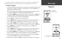
Page 32 highlights
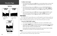
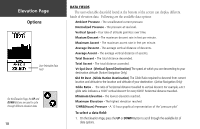
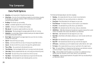
Trip Computer Data Field Options • Elevation-the measurement of height above mean sea level. • Glide Ratio-the ratio of horizontal distance travelled to vertical distance travelled. For example, a 6:1 glide ratio indicates a 1000' vertical descent for every 6000' horizontal distance travelled • Heading-the direction you are traveling. • Lat/Lon-(Latitude/Longitude) the current GPS position. • Location-shows your current latitude and longitude. • Max Speed-the maximum speed traveled since last reset. • Moving Avg-(Moving Average) the average speed while the unit is moving. • Odometer-a running tally of distance traveled, based upon the distance between second-by-second position readings. • Over'l Spd-(Overall Speed) the averaged speed since your last reset, including stopped and moving time. • Speed-shows how fast you are going. • Sunrise-the time at which the sun rises on this day at the specified location. • Sunset-the time at which the sun sets on this day at the specified location. • Time of Day-the current time for the selected time zone. • Time-Moving-the time elapsed while the unit is moving since the last trip reset. • Time-Stop-the time elapsed while the unit is not moving since the last trip reset. • Time-Total-the total time you have traveled since the last trip reset. • Trip Odom-(Trip Odometer) the total distance you've gone since the last reset. • Vert Speed-(Vertical Speed) the rate of altitude gain/loss over time. 20 The following fields display figures only when navigating: • Bearing-the compass direction from your location to your destination. • Course-the direction from your starting location to a destination. • Final Dest-(Final Destination) the last waypoint on your route. • Final Distance-the distance from your current location to your destination. • Final ETA-the estimated time you will arrive at your destination. • Final ETE-the estimated total time left until you reach your destination. • Gld Rt Dest-(Glide Ratio Destination) the glide ratio required to descend from current location and altitude to the location and altitude of your destination • Next Dest-(Next Destination) the next waypoint on your route. • Next Dist-(Next Distance) the distance between your current location and the next waypoint. • Next ETA-the estimated time you will arrive at the next waypoint. • Next ETE-the estimated total time left until you reach the next waypoint. • Off Course-the distance you are off a desired course in either direction, left or right. • To Course-the compass direction you must go to get back to the original course. • Turn-the angle difference (in degrees) from the bearing to your destination and your current line of travel. 'L' means turn Left, 'R' means turn Right. • Vmg-(Velocity Made Good) the speed you are closing in on a destination along a desired course. Also referred to as the 'vector velocity' to your destination. • Vt Spd Dest-(Vertical Speed Destination) the speed at which you are descending to your destination altitude
-
 1
1 -
2
-
3
-
4
-
5
-
6
-
7
-
8
-
9
-
10
-
11
-
12
-
13
-
14
-
15
-
16
-
17
-
18
-
19
-
20
-
21
-
22
-
23
-
24
-
25
-
26
-
 27
27 -
 28
28 -
 29
29 -
 30
30 -
 31
31 -
 32
32 -
 33
33 -
 34
34 -
 35
35 -
 36
36 -
 37
37 -
38
-
39
-
40
-
41
-
42
-
43
-
44
-
45
-
46
-
47
-
48
-
49
-
50
-
51
-
52
-
53
-
54
-
55
-
56
-
57
-
58
-
59
-
60
-
61
-
62
-
63
-
64
-
65
-
66
-
67
-
68
 |
 |