Garmin Geko 301 Owner's Manual - Page 53
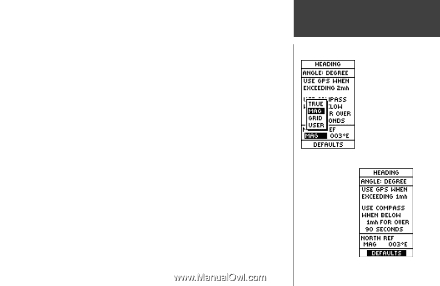
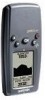
To change the North Reference
 |
UPC - 753759042073
View all Garmin Geko 301 manuals
Add to My Manuals
Save this manual to your list of manuals |
Page 53 highlights
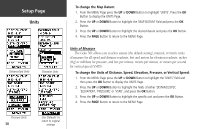
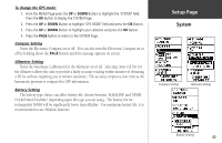
Because a compass points to Magnetic North, not True North, maps indicate the difference between True and Magnetic North with a measurement called 'declination'. The amount of declination changes as you move around the earth. Magnetic North is the direction in which a compass needle points. When the Geko 301 has your postion (i.e. "Ready to Navigate"), it corrects for declination when set to 'TRUE NORTH'. The Geko 301 bearings will correspond to the compass if the Geko 301 is set to magnetic north. Due to errors introduced when map makers flatten the earth's sphere onto paper, not all of the grid lines drawn on the map point exactly to the north pole, so the north indicated by the grid lines is called Grid North. The difference, however, is usually small enough that 'Grid' north can be considered the same as True North for traveling on land. If necessary, manually correct for the difference between Grid North and True North. If you select User for North Reference, the 'VARIATION' field is highlighted for you to edit the declination. The declination of the Geko 301's compass is shown to the right of North Reference. To change the North Reference: 1. From the MENU Page press the UP or DOWN Button to highlight 'UNITS' and then press the OK Button to display the UNITS Page. 2. Press the UP or DOWN Button to highlight the 'NORTH REF' field and press the OK Button. 3. Press the UP or DOWN Button to highlight your selection and then press the OK Button. 4. Press the PAGE Button to return to the MENU Page. When you select the 'DEFAULTS' field and press the OK Button to return the UNITS Page to the factory settings. Setup Page Heading 'MAGNETIC' north is the default north reference setting. Use 'Defaults' to return to original factory settings 41
-
 1
1 -
2
-
3
-
4
-
5
-
6
-
7
-
8
-
9
-
10
-
11
-
12
-
13
-
14
-
15
-
16
-
17
-
18
-
19
-
20
-
21
-
22
-
23
-
24
-
25
-
26
-
27
-
28
-
29
-
30
-
31
-
32
-
33
-
34
-
35
-
36
-
37
-
38
-
39
-
40
-
41
-
42
-
43
-
44
-
45
-
46
-
47
-
 48
48 -
 49
49 -
 50
50 -
 51
51 -
 52
52 -
 53
53 -
 54
54 -
 55
55 -
 56
56 -
 57
57 -
 58
58 -
59
-
60
-
61
-
62
-
63
-
64
-
65
-
66
-
67
-
68
 |
 |