2014 Chevrolet Volt Infotainment Manual - Page 50
2014 Chevrolet Volt Manual

Page 50 highlights
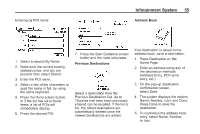
50 Infotainment System The waypoint symbol marks one or more set waypoints. A waypoint is a stopover destination point added to the planned route. The vehicle symbol indicates the current position and heading direction of the vehicle on the map. The estimated time and distance to the destination are displayed. Detailed Areas Road network attributes are contained in the map database for detailed areas. Attributes include information such as street names, street addresses, and turn restrictions. A detailed area includes all major highways, service roads, and residential roads. The detailed areas include points of interest (POIs) such as restaurants, airports, banks, hospitals, police stations, gas stations, tourist attractions, and historical monuments. The map database may not include data for newly constructed areas or map database corrections. The navigation system provides full route guidance in the detailed map areas. The destination symbol marks the final destination after a route has been planned. If waypoints have been added to the current route, each waypoint destination displays estimated time and distance. Navigation Symbols Following are the most common symbols that appear on a map screen.
-
 1
1 -
2
-
3
-
4
-
5
-
6
-
7
-
8
-
9
-
10
-
11
-
12
-
13
-
14
-
15
-
16
-
17
-
18
-
19
-
20
-
21
-
22
-
23
-
24
-
25
-
26
-
27
-
28
-
29
-
30
-
31
-
32
-
33
-
34
-
35
-
36
-
37
-
38
-
39
-
40
-
41
-
42
-
43
-
44
-
 45
45 -
 46
46 -
 47
47 -
 48
48 -
 49
49 -
 50
50 -
 51
51 -
 52
52 -
 53
53 -
 54
54 -
 55
55 -
56
-
57
-
58
-
59
-
60
-
61
-
62
-
63
-
64
-
65
-
66
-
67
-
68
-
69
-
70
-
71
-
72
-
73
-
74
-
75
-
76
-
77
-
78
-
79
-
80
-
81
-
82
-
83
-
84
-
85
-
86
-
87
-
88
-
89
-
90
-
91
-
92
-
93
-
94
-
95
-
96
-
97
-
98
 |
 |
