Garmin GPS 72 Owner's Manual - Page 12
Satellite Location, Satellite Strength Indicator Bars, Time and, Current Location - navigator
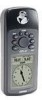 |
UPC - 689076719087
View all Garmin GPS 72 manuals
Add to My Manuals
Save this manual to your list of manuals |
Page 12 highlights
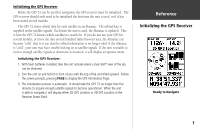
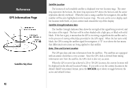
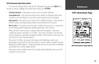
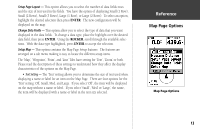
InRterofedruecntcioen GPS Information Page Satellite Sky View 10 Satellite Location The location of each available satellite is displayed over two location rings. The outer ring represents the horizon, the inner ring represents 45° above the horizon and the center represents directly overhead. When the unit is using a satellite for navigation, the satellite number will become highlighted on the location rings. The unit can be set to display satellite location with North, or your current track toward the top of the display. Satellite Strength Indicator Bars The Satellite Strength Indicator Bars show the strength of the signal being received, and the status of the signal. The bars will be either shaded with a light grey, or filled with solid black. If the bar is grey, it means that the GPS is receiving a signal from the satellite and is in the process of storing orbital data provided in the GPS signal. When the bar turns solid black, the GPS is using the satellite signal for navigation. A "D" in or above the bar means that differential corrections are being applied to that satellite. Date, Time and Current Location The GPS gets date and time information from the satellites. The satellites are equipped with an atomic clock that is very accurate. Since the GPS clock is derived from timing information sent from the satellite, the GPS clock is also very accurate. When the GPS receiver has achieved a 2D or 3D GPS Location, the current location will be displayed in the selected Location Format. If you wish to see the current location in the default (hddd° mm.mmm) format, press the ROCKER up or down to toggle between the active and default format.
-
 1
1 -
2
-
3
-
4
-
5
-
6
-
 7
7 -
 8
8 -
 9
9 -
 10
10 -
 11
11 -
 12
12 -
 13
13 -
 14
14 -
 15
15 -
 16
16 -
 17
17 -
18
-
19
-
20
-
21
-
22
-
23
-
24
-
25
-
26
-
27
-
28
-
29
-
30
-
31
-
32
-
33
-
34
-
35
-
36
-
37
-
38
-
39
-
40
-
41
-
42
-
43
-
44
-
45
-
46
-
47
-
48
-
49
-
50
-
51
-
52
-
53
-
54
-
55
-
56
-
57
-
58
-
59
-
60
-
61
-
62
-
63
-
64
-
65
-
66
-
67
 |
 |
