Garmin GPS 72 Owner's Manual - Page 14
Map - navaid database
 |
UPC - 689076719087
View all Garmin GPS 72 manuals
Add to My Manuals
Save this manual to your list of manuals |
Page 14 highlights
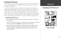
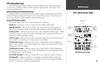
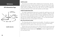
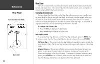
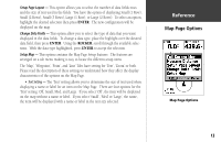
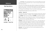
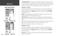
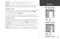
InRterofedruecntcioen Map Page User Selectable Data Fields Zoom Scale 12 Map Page The GPS 72 comes with a factory-loaded marine point database that includes marine navaids and major cities. This can be replaced with marine navaids, cities, and points of interest using GARMIN MapSource products. Changing the Zoom Scale You can change the Zoom Scale on the Map Page allowing you to view a smaller area in greater detail or a larger area with less detail. As referred to in this manual, when you decrease the Zoom Scale you will view a smaller area with greater detail. The current Zoom Scale setting is displayed in the lower left corner of the Map Page. If 'Overzoom' is displayed under the scale, no further map information is available. To change the Zoom Scale: 1. Press the IN Key to decrease the Zoom Scale. 2. Press the OUT Key to increase the Zoom Scale. Map Page Options To access the Map Page Options, with the Map Page displayed, press the MENU Key. To select an option from the Menu, highlight the desired selection then press ENTER. Full Screen Map - This option hides the data fields and expands the map to include the entire display. When 'Full Screen Map' is selected the option will change to 'Show Data Fields'. Measure Distance - This option will allow you to measure the distance between two points. As you move the Map Pointer, the Distance, Bearing and Location of the Pointer are displayed at the top of the map. To measure the distance between to map points, press ENTER to set a reference, then move the Map Pointer to the other location. The Bearing, and Distance are displayed below the data fields.
-
 1
1 -
2
-
3
-
4
-
5
-
6
-
7
-
8
-
 9
9 -
 10
10 -
 11
11 -
 12
12 -
 13
13 -
 14
14 -
 15
15 -
 16
16 -
 17
17 -
 18
18 -
 19
19 -
20
-
21
-
22
-
23
-
24
-
25
-
26
-
27
-
28
-
29
-
30
-
31
-
32
-
33
-
34
-
35
-
36
-
37
-
38
-
39
-
40
-
41
-
42
-
43
-
44
-
45
-
46
-
47
-
48
-
49
-
50
-
51
-
52
-
53
-
54
-
55
-
56
-
57
-
58
-
59
-
60
-
61
-
62
-
63
-
64
-
65
-
66
-
67
 |
 |
