Garmin GPS 72 Owner's Manual - Page 19
Saved Tracks, Course Line, Bearing Line, Setup Map - 'City' Tab, Setup Map - 'Other' Tab, Accuracy
 |
UPC - 689076719087
View all Garmin GPS 72 manuals
Add to My Manuals
Save this manual to your list of manuals |
Page 19 highlights
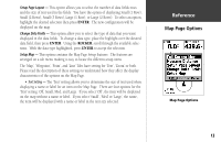
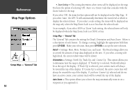
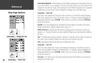
Saved Tracks - are Track Logs that have been saved in the units memory. Course Line - controls the display of the Route Line and Go To Line. Bearing Line - The Bearing Line will show the bearing from your current location to the active waypoint. This can be used to steer the shortest path to your waypoint. Setup Map - 'City' Tab The 'City' Tab contains the 'Text' and 'Zoom' settings for Large City, Medium City, Small City and Small Towns. To change a setting, highlight the field then press ENTER. Make your selection, then press ENTER to accept. The City settings are used to de-clutter the map. If 'Auto' is the selected 'Zoom' setting, the Large and Medium cities will be displayed at a higher Map Zoom Scale setting. Setup Map - 'Other' Tab The 'Other' Tab contains the 'Text' and 'Zoom' settings for Railroad and an On/Off setting for the Accuracy Circle. To change a setting, highlight the appropriate field then press ENTER. Make your new selection, then press ENTER to accept the selection. Accuracy Circle - The Accuracy Circle is displayed around the current location on the Map Page. The Accuracy Circle depicts the estimated accuracy of the location. Heading Line - If the Heading line is 'On', a line showing your current heading will be projected on the map from the current location. The Heading line is a thin black line. InRterofedruecntcioen Map Page Options Setup Map - 'Line' Tab Setup Map - 'City' Tab 17
-
 1
1 -
2
-
3
-
4
-
5
-
6
-
7
-
8
-
9
-
10
-
11
-
12
-
13
-
 14
14 -
 15
15 -
 16
16 -
 17
17 -
 18
18 -
 19
19 -
 20
20 -
 21
21 -
 22
22 -
 23
23 -
 24
24 -
25
-
26
-
27
-
28
-
29
-
30
-
31
-
32
-
33
-
34
-
35
-
36
-
37
-
38
-
39
-
40
-
41
-
42
-
43
-
44
-
45
-
46
-
47
-
48
-
49
-
50
-
51
-
52
-
53
-
54
-
55
-
56
-
57
-
58
-
59
-
60
-
61
-
62
-
63
-
64
-
65
-
66
-
67
 |
 |
