Garmin GPS 72 Owner's Manual - Page 29
Create Waypoint Options Menu, Average Location, Project Location, Project Location Options, - accuracy
 |
UPC - 689076719087
View all Garmin GPS 72 manuals
Add to My Manuals
Save this manual to your list of manuals |
Page 29 highlights
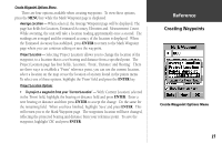
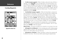
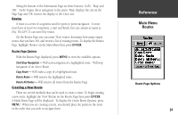
Create Waypoint Options Menu There are four options available when creating waypoints. To view these options, press the MENU key while the Mark Waypoint page is displayed. Average Location - When selected, the Average Waypoint page will be displayed. The page has fields for Location, Estimated Accuracy, Elevation and Measurement Count. While averating, the unit will take a location reading approximatly once a second. The readings are averaged and the estimated accuracy of the location is displayed. When the Estimated Accuracy has stabilized, press ENTER to return to the Mark Waypoint page where you can continue editing or save the waypoint. Project Location - Selecting 'Project Location' allows you to change the location of the waypoint, to a location that is a set bearing and distance from a specified point. The Project Location page has four fields, 'Location', 'From', 'Distance' and 'Bearing'. There are three ways to establish a "From" reference point, you can use the current location, select a location on the map or use the location of an item found in the points menu. To select one of these options, highlight the 'From' field and press the ENTER key. Project Location Options • To project a waypoint from your 'Current Location' - With 'Current Location' selected in the 'From' field, highlight the bearing or distance field and press ENTER. Enter a new bearing or distance and then press ENTER to accept the change. Do the same for the remaining field. When you have finished, highlight 'Save' and press ENTER. This will return you to the Mark Waypoint page. The waypoints location will have changed, reflecting the projected bearing and distance from your reference point. To save the waypoint, highlight 'OK' and press ENTER. InRterofedruecntcioen Creating Waypoints Create Waypoint Options Menu 27
-
 1
1 -
2
-
3
-
4
-
5
-
6
-
7
-
8
-
9
-
10
-
11
-
12
-
13
-
14
-
15
-
16
-
17
-
18
-
19
-
20
-
21
-
22
-
23
-
 24
24 -
 25
25 -
 26
26 -
 27
27 -
 28
28 -
 29
29 -
 30
30 -
 31
31 -
 32
32 -
 33
33 -
 34
34 -
35
-
36
-
37
-
38
-
39
-
40
-
41
-
42
-
43
-
44
-
45
-
46
-
47
-
48
-
49
-
50
-
51
-
52
-
53
-
54
-
55
-
56
-
57
-
58
-
59
-
60
-
61
-
62
-
63
-
64
-
65
-
66
-
67
 |
 |
