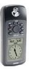
Garmin GPS 72 Owner's Manual - Page 13
Start/Stop Simulator, Track Up/North Up, New Elevation, New Location - map
 |
UPC - 689076719087
View all Garmin GPS 72 manuals
Add to My Manuals
Save this manual to your list of manuals |
Page 13 highlights
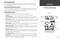
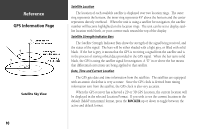
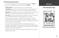
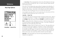
GPS Information Page Options Menu To activate the Options Menu, from the GPS Information Page press the MENU Key. To select an option, highlight the desired selection then press ENTER. Start/Stop Simulator - This option is used to Start or Stop the Simulator. Track Up/North Up - This option determines if the satellites are displayed with North toward the top of the display or your current track toward the top of the display. New Elevation - This option can be used to enter a different elevation. If the GPS has a 2D GPS Location, entering a known elevation can increase the GPS accuracy. New Location - If you have moved the unit to another state, province, or country, and you are having trouble locking onto satellite signals select 'New Location'. When you select 'New Location', an options menu will be displayed. This menu contains the options 'Automatic' or 'Use Map'. If you select 'Automatic', the unit will switch to AutoLocate and begin searching for satellites. This method can take up to five minutes for the unit to begin navigation. If you select 'Use Map', you can use the Pointer on the Map Page to select your approximate location and the unit will continue to acquire satellites normally using the almanac for satellite reference. Using this method, the unit does not need to reinitialize and should receive satellite signals quickly. If the unit is in the 'Simulator' mode, the 'Use Map' feature will allow you to move the simulated current location. InRterofedruecntcioen GPS Information Page GPS Information Page Options 11
-
 1
1 -
2
-
3
-
4
-
5
-
6
-
7
-
 8
8 -
 9
9 -
 10
10 -
 11
11 -
 12
12 -
 13
13 -
 14
14 -
 15
15 -
 16
16 -
 17
17 -
 18
18 -
19
-
20
-
21
-
22
-
23
-
24
-
25
-
26
-
27
-
28
-
29
-
30
-
31
-
32
-
33
-
34
-
35
-
36
-
37
-
38
-
39
-
40
-
41
-
42
-
43
-
44
-
45
-
46
-
47
-
48
-
49
-
50
-
51
-
52
-
53
-
54
-
55
-
56
-
57
-
58
-
59
-
60
-
61
-
62
-
63
-
64
-
65
-
66
-
67
 |
 |
