Magellan 330X User Manual - Page 37
Magellan 330X - GPS Map Manual
 |
UPC - 763357102796
View all Magellan 330X manuals
Add to My Manuals
Save this manual to your list of manuals |
Page 37 highlights
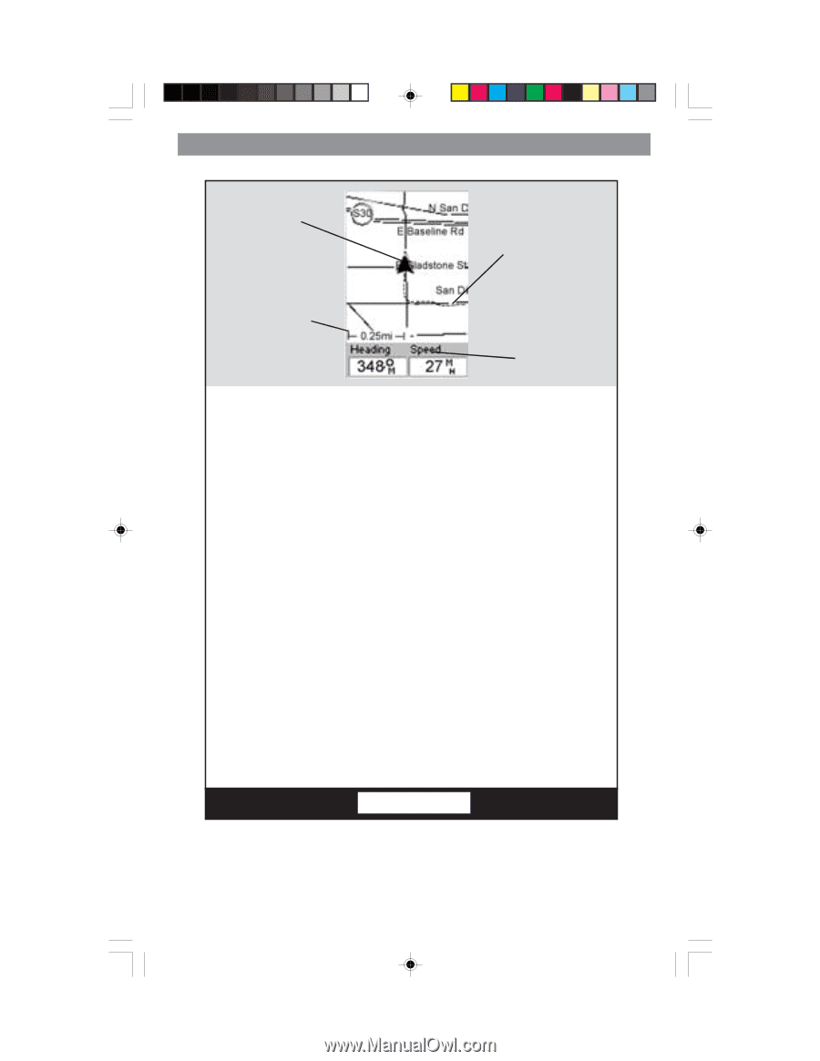
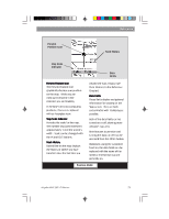
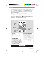
Reference Present Position Icon Track History Map Scale Indicator Data Fields Present Position Icon The Present Position Icon graphically displays your position on the map. While you are moving it will point in the direction you are heading. If the MAP 330 is not computing positions, this icon is replaced with an hourglass icon. Map Scale Indicator Provides the scale for the map. The number displayed represents approximately 1/4 of the screen's width. Scale can be changed with the IN and OUT buttons. Track History Dotted line on the map displays the history of where you have travelled since the last time you cleared the Track History (see Clear Memory in the Reference Chapter.) Data Fields These fields display navigational information for viewing on the Map screen. They are both customizable with 13 data types possible. Both of the data fields can be turned on or off allowing more viewable map area. Both features (customize and turning the data on/off) can be accessed from the MENU button. Optionally, using the customize function, the data fields can be replaced with the name of the street or intersection you are presently on. Position Mode Magellan MAP 330 GPS Receiver 25
-
 1
1 -
2
-
3
-
4
-
5
-
6
-
7
-
8
-
9
-
10
-
11
-
12
-
13
-
14
-
15
-
16
-
17
-
18
-
19
-
20
-
21
-
22
-
23
-
24
-
25
-
26
-
27
-
28
-
29
-
30
-
31
-
 32
32 -
 33
33 -
 34
34 -
 35
35 -
 36
36 -
 37
37 -
 38
38 -
 39
39 -
 40
40 -
 41
41 -
 42
42 -
43
-
44
-
45
-
46
-
47
-
48
-
49
-
50
-
51
-
52
-
53
-
54
-
55
-
56
-
57
-
58
-
59
-
60
-
61
-
62
-
63
-
64
-
65
-
66
-
67
-
68
-
69
-
70
-
71
-
72
-
73
-
74
-
75
-
76
-
77
-
78
-
79
-
80
-
81
-
82
-
83
-
84
-
85
-
86
-
87
-
88
-
89
-
90
-
91
-
92
-
93
-
94
 |
 |