Magellan 330X User Manual - Page 88
Magellan 330X - GPS Map Manual
 |
UPC - 763357102796
View all Magellan 330X manuals
Add to My Manuals
Save this manual to your list of manuals |
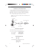
Page 88 highlights
Appendix ETE Estimated Time Enroute. The estimated time remaining to reach the next waypoint in a route. Heading. The direction you are facing, defined as an angle from North. The angular distance north or south of the equator measured by lines encircling the earth parallel to the equator from 0˚ to 90˚. Coordinate system using latitude and longitude coordinates to define a position on the earth. A segment of a route that has a starting (FROM) waypoint and a destination (TO) waypoint. A route may consist of 1 or more legs. A route that is from waypoint A to waypoint B to waypoint C to waypoint D has three legs with the first being from waypoint A to waypoint B. The angular distance east or west of the prime meridian (Greenwich Meridian) as measured by lines perpendicular to the parallels and converging at the poles from 0˚ to 180˚. HDG Latitude LAT/LON Leg (Route) Longitude Magnetic North NMEA The direction relative to a magnetic compass. National Marine Electronics Association. A professional organization that defines and maintains the standard serial format used by marine electronic navigation equipment and computer interfaces. A coordinate system describing only Great Britain, similar to UTMs. Used with GRB36 datum. Position coordinates as computed by the MAP 330. Speed Over Ground. The speed at which the receiver is moving. Temperature. OSGB Position fix SOG TMP 76 Magellan MAP 330 GPS Receiver
-
 1
1 -
2
-
3
-
4
-
5
-
6
-
7
-
8
-
9
-
10
-
11
-
12
-
13
-
14
-
15
-
16
-
17
-
18
-
19
-
20
-
21
-
22
-
23
-
24
-
25
-
26
-
27
-
28
-
29
-
30
-
31
-
32
-
33
-
34
-
35
-
36
-
37
-
38
-
39
-
40
-
41
-
42
-
43
-
44
-
45
-
46
-
47
-
48
-
49
-
50
-
51
-
52
-
53
-
54
-
55
-
56
-
57
-
58
-
59
-
60
-
61
-
62
-
63
-
64
-
65
-
66
-
67
-
68
-
69
-
70
-
71
-
72
-
73
-
74
-
75
-
76
-
77
-
78
-
79
-
80
-
81
-
82
-
 83
83 -
 84
84 -
 85
85 -
 86
86 -
 87
87 -
 88
88 -
 89
89 -
 90
90 -
 91
91 -
 92
92 -
 93
93 -
94
 |
 |