Magellan 330X User Manual - Page 47
Magellan 330X - GPS Map Manual
 |
UPC - 763357102796
View all Magellan 330X manuals
Add to My Manuals
Save this manual to your list of manuals |
Page 47 highlights
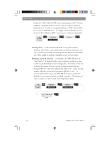
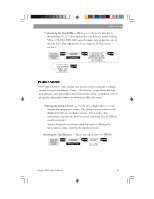
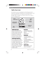
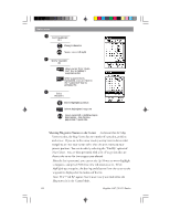
Reference Customizing the Data Fields - Allows you to change the data that is being display to 1 of 13 data options (bearing, distance, speed, heading, VMG, CTS, ETA, ETE, XTE, turn, elevation, time, or date) for any of the four fields. (See explanation of Data Types in the Map Screen section.) From the Large Data Screen MENU Highlight Customize ENTER Use arrows to highlight the title for the data field to be changed ENTER Use arrows to select new data type ENTER The Position screens 1 and 2 display your present position using the coordinate systems that you have selected in Setup. The Position 1 screen shows all of the basic position, time and satellite information on one screen. In addition, current navigation information is shown in the bottom half of the screen. Selecting the Position Screen - Use the Left or Right arrows to switch between the two position screens. This allows the same position to be displayed in different coordinate systems. This is useful when comparing navigation data between devices and charts that use different coordinate systems. You can change the coordinate system displayed by following the instructions in Setup - Selecting the Coordinate System. Resetting the Trip Odometer - Resets the trip odometer to 0000.00. From the Position Screen MENU Highlight Reset Trip ENTER Confirm? Yes or No ENTER Magellan MAP 330 GPS Receiver 35
-
 1
1 -
2
-
3
-
4
-
5
-
6
-
7
-
8
-
9
-
10
-
11
-
12
-
13
-
14
-
15
-
16
-
17
-
18
-
19
-
20
-
21
-
22
-
23
-
24
-
25
-
26
-
27
-
28
-
29
-
30
-
31
-
32
-
33
-
34
-
35
-
36
-
37
-
38
-
39
-
40
-
41
-
 42
42 -
 43
43 -
 44
44 -
 45
45 -
 46
46 -
 47
47 -
 48
48 -
 49
49 -
 50
50 -
 51
51 -
 52
52 -
53
-
54
-
55
-
56
-
57
-
58
-
59
-
60
-
61
-
62
-
63
-
64
-
65
-
66
-
67
-
68
-
69
-
70
-
71
-
72
-
73
-
74
-
75
-
76
-
77
-
78
-
79
-
80
-
81
-
82
-
83
-
84
-
85
-
86
-
87
-
88
-
89
-
90
-
91
-
92
-
93
-
94
 |
 |