Magellan 330X User Manual - Page 89
Magellan 330X - GPS Map Manual
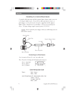
 |
UPC - 763357102796
View all Magellan 330X manuals
Add to My Manuals
Save this manual to your list of manuals |
Page 89 highlights
Appendix True North The direction to North Pole from an observer's position. The north direction on any geographical meridian. Universal Time Coordinated. Formerly referred to as Greenwich Mean Time (GMT). Universal Transverse Mercator metric grid system used on most large and intermediate scale land topographic charts and maps. Velocity Made Good. The component of the velocity that is in the direction of the destination. Waypoint. A location saved in the receiver's memory which is obtained by entering data, editing data, calculating data or saving a current position. Used to create routes. Cross Track Error. The perpendicular distance between the present position and the courseline. Given as a distance, right or left, of course when facing the destination. UTC UTM VMG WPT XTE Magellan MAP 330 GPS Receiver 77
-
 1
1 -
2
-
3
-
4
-
5
-
6
-
7
-
8
-
9
-
10
-
11
-
12
-
13
-
14
-
15
-
16
-
17
-
18
-
19
-
20
-
21
-
22
-
23
-
24
-
25
-
26
-
27
-
28
-
29
-
30
-
31
-
32
-
33
-
34
-
35
-
36
-
37
-
38
-
39
-
40
-
41
-
42
-
43
-
44
-
45
-
46
-
47
-
48
-
49
-
50
-
51
-
52
-
53
-
54
-
55
-
56
-
57
-
58
-
59
-
60
-
61
-
62
-
63
-
64
-
65
-
66
-
67
-
68
-
69
-
70
-
71
-
72
-
73
-
74
-
75
-
76
-
77
-
78
-
79
-
80
-
81
-
82
-
83
-
 84
84 -
 85
85 -
 86
86 -
 87
87 -
 88
88 -
 89
89 -
 90
90 -
 91
91 -
 92
92 -
 93
93 -
 94
94
 |
 |