Canon XC15 User Manual - Page 100
Recording GPS Information (Geotagging), Connecting the GPS Receiver
 |
View all Canon XC15 manuals
Add to My Manuals
Save this manual to your list of manuals |
Page 100 highlights
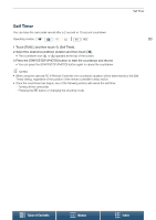
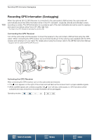
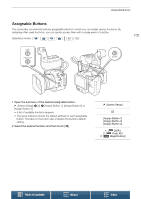
Recording GPS Information (Geotagging) Recording GPS Information (Geotagging) 100 When the optional GP-E2 GPS Receiver is connected to the camcorder's USB terminal, the camcorder will automatically record the GPS information (time in the UTC standard*, longitude, latitude and altitude) to every recording you make. The GPS information is recorded as part of the clip's metadata and can be used to organize and search recordings using Canon XF Utility (A 122). * The time in the UTC standard is recorded for photos only. Connecting the GPS Receiver Turn off the camcorder and the receiver. Connect the receiver to the camcorder's USB terminal using the USB cable*. When connecting the GPS receiver, we recommend putting it in the carrying case supplied with the GPS receiver and carrying it on your waist. For details about using the receiver, refer to the GP-E2 Instruction Manual. * Supplied with the optional GP-E2 GPS Receiver. USB terminal Activating the GPS Receiver After connecting the GPS receiver, turn on the camcorder and receiver. • The icon appears on the right of the screen and will flash as the receiver tries to acquire satellite signals. • When satellite signals are correctly acquired, the icon will stay continuously on. GPS functions will be activated and clips and photos recorded thereafter will be geotagged. Operating modes: Table of Contents Menus Index
-
 1
1 -
2
-
3
-
4
-
5
-
6
-
7
-
8
-
9
-
10
-
11
-
12
-
13
-
14
-
15
-
16
-
17
-
18
-
19
-
20
-
21
-
22
-
23
-
24
-
25
-
26
-
27
-
28
-
29
-
30
-
31
-
32
-
33
-
34
-
35
-
36
-
37
-
38
-
39
-
40
-
41
-
42
-
43
-
44
-
45
-
46
-
47
-
48
-
49
-
50
-
51
-
52
-
53
-
54
-
55
-
56
-
57
-
58
-
59
-
60
-
61
-
62
-
63
-
64
-
65
-
66
-
67
-
68
-
69
-
70
-
71
-
72
-
73
-
74
-
75
-
76
-
77
-
78
-
79
-
80
-
81
-
82
-
83
-
84
-
85
-
86
-
87
-
88
-
89
-
90
-
91
-
92
-
93
-
94
-
 95
95 -
 96
96 -
 97
97 -
 98
98 -
 99
99 -
 100
100 -
 101
101 -
 102
102 -
 103
103 -
 104
104 -
 105
105 -
106
-
107
-
108
-
109
-
110
-
111
-
112
-
113
-
114
-
115
-
116
-
117
-
118
-
119
-
120
-
121
-
122
-
123
-
124
-
125
-
126
-
127
-
128
-
129
-
130
-
131
-
132
-
133
-
134
-
135
-
136
-
137
-
138
-
139
-
140
-
141
-
142
-
143
-
144
-
145
-
146
-
147
-
148
-
149
-
150
-
151
-
152
-
153
-
154
-
155
-
156
-
157
-
158
-
159
-
160
-
161
-
162
-
163
-
164
-
165
-
166
-
167
-
168
-
169
-
170
-
171
-
172
 |
 |
