Garmin 2620 Owners Manual - Page 17
Using the Map Scale
 |
UPC - 753759045449
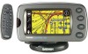
View all Garmin 2620 manuals
Add to My Manuals
Save this manual to your list of manuals |
Page 17 highlights
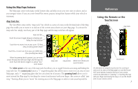
to Track Up (or vice versa) by touching the orientation icon. Note that the map tools bar must be hidden before you can change these icons. Map Scale A map scale appears on the lower left of the Map page. It shows you the current zoom level showing on the Map page (such as 500 miles, .8 miles, or 200 feet) as well as what map your StreetPilot is using to create the current image. Your StreetPilot includes a "base map" and a "detail map." The base map provides only general information such as city names and highway exits. The detail map includes specific details such as businesses, parks, and other points of interest. Thus, if you are viewing Denver at a map scale of 800 feet, your StreetPilot will display information from its base map. The map scale will switch from "base map" to "detail map" as you continue to zoom in to Denver. If you continue to zoom in to Denver or any city, "overzoom" will appear on the map scale. Displaying at around 500 - 300 feet, "overzoom" indicates that the current scale exceeds the optimum resolution of available map detail. Some detail, such as roads, are drawn using widelyspaced points and the actual layout of these details may differ from the map presentation. base map of Denver at 20-mile zoom detail map of Denver at 800-foot zoom detail map of Denver at 300-foot "overzoom" Reference Using the Map Scale 9
-
 1
1 -
2
-
3
-
4
-
5
-
6
-
7
-
8
-
9
-
10
-
11
-
 12
12 -
 13
13 -
 14
14 -
 15
15 -
 16
16 -
 17
17 -
 18
18 -
 19
19 -
 20
20 -
 21
21 -
 22
22 -
23
-
24
-
25
-
26
-
27
-
28
-
29
-
30
-
31
-
32
-
33
-
34
-
35
-
36
-
37
-
38
-
39
-
40
-
41
-
42
-
43
-
44
-
45
-
46
-
47
-
48
-
49
-
50
-
51
-
52
-
53
-
54
-
55
-
56
-
57
-
58
-
59
-
60
-
61
-
62
-
63
-
64
-
65
-
66
-
67
-
68
-
69
-
70
-
71
-
72
-
73
-
74
-
75
-
76
-
77
-
78
-
79
-
80
-
81
-
82
-
83
-
84
-
85
-
86
-
87
-
88
-
89
-
90
-
91
-
92
-
93
 |
 |
