Garmin 2620 Owners Manual - Page 65
GPS Info Sky View and Signal Strength Bars - streetpilot update
 |
UPC - 753759045449
View all Garmin 2620 manuals
Add to My Manuals
Save this manual to your list of manuals |
Page 65 highlights
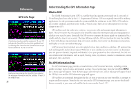
Sky View Satellites Signal strength bars A signal strength bar appears for each satellite in view; the satellite's number appears beneath each bar. The progress of satellite acquisition is shown in three stages: • No signal strength bar: The GPS receiver in your StreetPilot is looking for the satellite(s) indicated. The corresponding number(s) on the sky view is not highlighted. • Hollow signal strength bar: The GPS receiver has found the satellite and is collecting data. The corresponding number(s) on the sky view is highlighted in pink. • Solid green signal strength bar: The GPS receiver has collected the necessary data and the satellite(s) is ready for use. The corresponding number(s) on the sky view is highlighted in green. Each satellite has a 30-second data transmission that must be collected (hollow signal strength bar, as described above) before that satellite can be used for navigation (solid green signal strength bar). Once a fix has been calculated, the StreetPilot then updates your position, ground track, and ground speed by selecting and using the best satellites in view. Sky View and Signal Strength Bars The sky view and signal strength bars give you an indication of which satellites are currently visible, which satellites are being used to calculate a position fix, and the signal quality. The sky view provides a "bird's eye" view of each satellite position relative to your unit's last known position. The outer circle represents the horizon in all directions (with cardinal heading references). The inner circle represents an elevation of 45° above the horizon. Any satellite depicted near the center is directly overhead. You can use the sky view to help determine whether any satellites are being blocked and whether you have a current position fix (indicated by 2D Navigation or 3D Navigation in the Satellite Status field). You can also set the Reference GPS Info Page 'Acquiring Sats' means the receiver is collecting data from available satellites but has not collected enough data to calculate a position fix. 'GPS is Off' tells you the unit is being used indoors and cannot be used for navigation. 57
-
 1
1 -
2
-
3
-
4
-
5
-
6
-
7
-
8
-
9
-
10
-
11
-
12
-
13
-
14
-
15
-
16
-
17
-
18
-
19
-
20
-
21
-
22
-
23
-
24
-
25
-
26
-
27
-
28
-
29
-
30
-
31
-
32
-
33
-
34
-
35
-
36
-
37
-
38
-
39
-
40
-
41
-
42
-
43
-
44
-
45
-
46
-
47
-
48
-
49
-
50
-
51
-
52
-
53
-
54
-
55
-
56
-
57
-
58
-
59
-
 60
60 -
 61
61 -
 62
62 -
 63
63 -
 64
64 -
 65
65 -
 66
66 -
 67
67 -
 68
68 -
 69
69 -
 70
70 -
71
-
72
-
73
-
74
-
75
-
76
-
77
-
78
-
79
-
80
-
81
-
82
-
83
-
84
-
85
-
86
-
87
-
88
-
89
-
90
-
91
-
92
-
93
 |
 |
