Garmin 2620 Owners Manual - Page 31
Finding an Exit, Near Here, Near [Destination], Near Map Pointer, By Name
 |
UPC - 753759045449
View all Garmin 2620 manuals
Add to My Manuals
Save this manual to your list of manuals |
Page 31 highlights
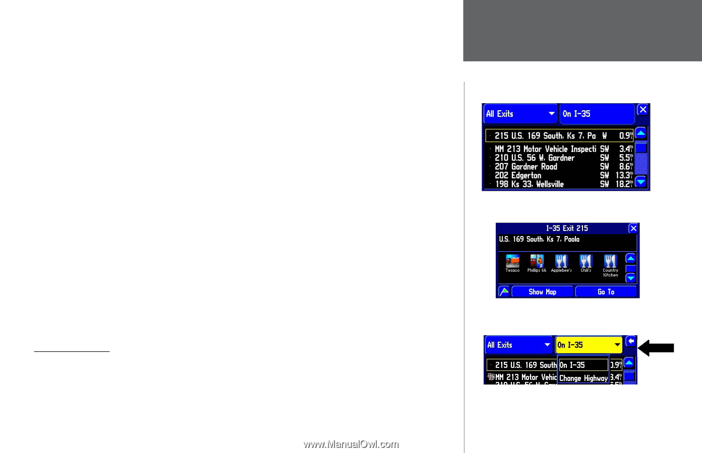
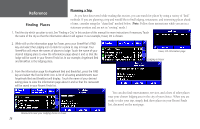
In addition to the Near Current Route tab, here are additional tab options for finding places: •Near Here: Whereas Near Current Route lists places along your entire route, Near Here finds places that are near your current physical location. •Near [Destination]: Use Near [Destination] to find places that are located at the end of your route. Thus, if you are travelling to Phoenix, the Near Phoenix tab will return places that are only within the vicinity of Phoenix. •Near Map Pointer: Use Near Map Pointer to find places that are near the area to which you have placed the map pointer while panning. •By Name: Use By Name to spell out the name of the place you seek; use the mini keyboard that appears when you select By Name. Note that when you use By Name, all places that are loaded in your mapping software will be searched. For example, if you are searching for McDonald's, your search will return a list of all McDonald's in the U.S. •Near Other: Use Near Other to find a place that is not in your immediate location. See the discussion on using Near Other in the Finding a City topic in this section of the manual. When you find the name of the restaurant or other place you seek (no matter which search method you used), touch the name of the restaurant and its address and telephone number will appear. Touch the green flag in the lower left-hand side of the screen if you want to mark the eatery as a waypoint, or Show Map if you want to see it on the Map page (see page 10 for an example), or Go To if you want your StreetPilot to navigate to the restaurant. Finding an Exit Select Exits from the Find menu to locate exits on highways, freeways, and interstates throughout the U.S. This is useful information if you are travelling and need to stop at an exit with a service station or when you need to find the nearest rest area. When you initially select Exits, your StreetPilot lists all exits on the highway or interstate that are closest to your current location. If you are driving on Interstate 40 near Albuquerque, for example, your StreetPilot will list all upcoming exits on I-40. Use the scroll bar on the Reference Finding Places Once you locate the exit of your choice, select it to display an information page for that item. This particular exit indicates that many services exist. Touch the icon to view information about a service. Change the highway or interstate by selecting the 'On I-35' tab and selecting Change Highway. 23
-
 1
1 -
2
-
3
-
4
-
5
-
6
-
7
-
8
-
9
-
10
-
11
-
12
-
13
-
14
-
15
-
16
-
17
-
18
-
19
-
20
-
21
-
22
-
23
-
24
-
25
-
 26
26 -
 27
27 -
 28
28 -
 29
29 -
 30
30 -
 31
31 -
 32
32 -
 33
33 -
 34
34 -
 35
35 -
 36
36 -
37
-
38
-
39
-
40
-
41
-
42
-
43
-
44
-
45
-
46
-
47
-
48
-
49
-
50
-
51
-
52
-
53
-
54
-
55
-
56
-
57
-
58
-
59
-
60
-
61
-
62
-
63
-
64
-
65
-
66
-
67
-
68
-
69
-
70
-
71
-
72
-
73
-
74
-
75
-
76
-
77
-
78
-
79
-
80
-
81
-
82
-
83
-
84
-
85
-
86
-
87
-
88
-
89
-
90
-
91
-
92
-
93
 |
 |