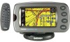
Garmin 2620 Owners Manual - Page 68
To select a new location
 |
UPC - 753759045449
View all Garmin 2620 manuals
Add to My Manuals
Save this manual to your list of manuals |
Page 68 highlights
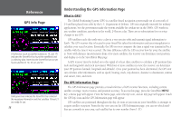
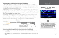
Reference GPS Info Page A 'D' on various signal strength bars above indicate which GPS satellites are being differentially corrected via WAAS satellites. Note that if the signal strength bar is too short, the 'D' will appear above the bar, as with satellite 26. GPS satellites can be differentially corrected via WAAS satellites even before your StreetPilot communicates with the GPS satellites, as is the case with Satellite 5, above. 60 To select a new location: 1. Select 'New Location.' A window appears with two options ('Automatic' and 'Use Map'). 2. Select either 'Automatic' or 'Use Map.' Selecting 'Automatic' puts the unit in Autolocate mode and begins searching the sky for satellites. For 'Use Map,' a 'New Location' map page appears. 3. If 'Use Map' is selected, pan and zoom the map pointer on the map to find your approximate location. Then touch the checkmark in the upper right-hand side of the page. New Elevation - Allows you to designate your approximate elevation when the StreetPilot is acquiring satellites or navigating within a two-dimensional position. By default, 2D navigation attempts to use the last known elevation. If the elevation shown is off by several hundred feet (or more), manually entering your approximate elevation enables the receiver to more accurately determine a position fix. Once the unit has a 3D position, you cannot enter an elevation. Enable WAAS - Allows you to improve position accuracy by using Wide Area Augmentation System (WAAS) capability. WAAS is a system of satellites and ground stations that provide GPS signal corrections, giving you even better position accuracy. WAAS corrects for GPS signal errors caused by ionospheric disturbances, timing, and satellite orbit errors, and it provides vital integrity information regarding the health of each GPS satellite. View the GPS Information page to see which GPS satellites are receiving position corrections from the WAAS satellites. A "D" will appear on the signal strength bar for GPS satellites that have been "Differentially corrected" via the WAAS satellites. Note: Because WAAS information is broadcast from fixed satellites over the equator, it is possible for obstructions commonly found in vehicles to block the view of these satellites. When this occurs, WAAS reception may be unavailable even though normal GPS reception remains unaffected and fully operational. To improve WAAS reception under all conditions, consider using an external GPS antenna such as a Garmin GA 27C. Mount it in an unobstructed location.
-
 1
1 -
2
-
3
-
4
-
5
-
6
-
7
-
8
-
9
-
10
-
11
-
12
-
13
-
14
-
15
-
16
-
17
-
18
-
19
-
20
-
21
-
22
-
23
-
24
-
25
-
26
-
27
-
28
-
29
-
30
-
31
-
32
-
33
-
34
-
35
-
36
-
37
-
38
-
39
-
40
-
41
-
42
-
43
-
44
-
45
-
46
-
47
-
48
-
49
-
50
-
51
-
52
-
53
-
54
-
55
-
56
-
57
-
58
-
59
-
60
-
61
-
62
-
 63
63 -
 64
64 -
 65
65 -
 66
66 -
 67
67 -
 68
68 -
 69
69 -
 70
70 -
 71
71 -
 72
72 -
 73
73 -
74
-
75
-
76
-
77
-
78
-
79
-
80
-
81
-
82
-
83
-
84
-
85
-
86
-
87
-
88
-
89
-
90
-
91
-
92
-
93
 |
 |
