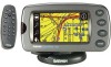
Garmin 2620 Owners Manual - Page 64
Understanding the GPS Information What is GPS?, The GPS Information
 |
UPC - 753759045449
View all Garmin 2620 manuals
Add to My Manuals
Save this manual to your list of manuals |
Page 64 highlights
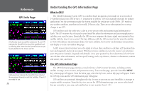
Reference GPS Info Page A hollow bar (such as satellite numbers 6, 15, and 17) indicates the StreetPilot has found the satellite(s) and is collecting data. Note how the StreetPilot has not yet found satellites 9, 10, 16, 22, and 23. Solid green bars indicate the StreetPilot has collected the necessary information and that satellites 18 and 21 are ready for use. 56 Understanding the GPS Information Page What is GPS? The Global Positioning System (GPS) is a satellite-based navigation system made up of a network of 24 satellites placed into orbit by the U.S. Department of Defense. GPS was originally intended for military applications, but the government made the system available for civilian use in the 1980s. GPS works in any weather condition, anywhere in the world, 24 hours a day. There are no subscription fees or setup charges to use GPS. GPS satellites circle the earth twice a day in a very precise orbit and transmit signal information to Earth. The GPS receiver that is located in your StreetPilot takes this information and uses triangulation to calculate your exact location. Essentially, the GPS receiver compares the time a signal was transmitted by a satellite with the time it was received. The time difference tells the GPS receiver how far away the satellite is. Now, with distance measurements from a few more satellites, the receiver can determine your position and display it on the StreetPilot's Map page. A GPS receiver must be locked on to the signal of at least three satellites to calculate a 2D position (latitude and longitude) and track movement. With four or more satellites in view, the receiver can determine your 3D position (latitude, longitude and altitude). Once your position has been determined, the GPS unit can calculate other information, such as speed, bearing, track, trip distance, distance to destination, sunrise and sunset, time, and more. The GPS Information Page The GPS Information page provides a visual reference of GPS receiver functions, including current satellite coverage, receiver status, and position accuracy. To access this page, press the StreetPilot MENU key; a Menu page will appear. From the Menu page, select the Info icon, and an Info page will appear. Touch the GPS Info icon and the GPS Information page will appear. GPS satellites are positioned throughout the sky. As soon as you turn on your StreetPilot, it attempts to acquire satellite reception. From the sky view area on the GPS Information page, you can see which satellites are currently in your area; each satellite has its own number (from 1-31).
-
 1
1 -
2
-
3
-
4
-
5
-
6
-
7
-
8
-
9
-
10
-
11
-
12
-
13
-
14
-
15
-
16
-
17
-
18
-
19
-
20
-
21
-
22
-
23
-
24
-
25
-
26
-
27
-
28
-
29
-
30
-
31
-
32
-
33
-
34
-
35
-
36
-
37
-
38
-
39
-
40
-
41
-
42
-
43
-
44
-
45
-
46
-
47
-
48
-
49
-
50
-
51
-
52
-
53
-
54
-
55
-
56
-
57
-
58
-
 59
59 -
 60
60 -
 61
61 -
 62
62 -
 63
63 -
 64
64 -
 65
65 -
 66
66 -
 67
67 -
 68
68 -
 69
69 -
70
-
71
-
72
-
73
-
74
-
75
-
76
-
77
-
78
-
79
-
80
-
81
-
82
-
83
-
84
-
85
-
86
-
87
-
88
-
89
-
90
-
91
-
92
-
93
 |
 |
