Garmin GPSMAP 541s Owner's Manual - Page 14
Using Charts, Using the Navigation Chart
 |
UPC - 753759096045
View all Garmin GPSMAP 541s manuals
Add to My Manuals
Save this manual to your list of manuals |
Page 14 highlights
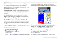
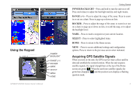
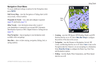
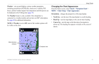
Using Charts Using Charts Your chartplotter has a worldwide map and a built-in detailed map of US inland lakes, or BlueChart g2 cartography for the USA and Bahamas shoreline. • Navigation Chart-displays all relevant navigation data available on your preloaded maps, including buoys, lights, cables, depth soundings, marinas, and tide stations, in an overhead view. • Perspective 3D-provides a view from above and behind the boat (according to your course), and provides a visual navigation aid. • Split Navigation Chart-displays two different zoom levels of the Navigation chart at the same time. Fishing charts, Fish Eye 3D, and Mariner's Eye 3D views are available when using optional BlueChart g2 Vision preprogrammed SD cards. • Fishing Chart-provides a view of the chart with enhanced bottom contours and without navigational data. This chart works well for offshore deep-sea fishing. • Fish Eye 3D-provides an underwater 3D view that visually represents the sea floor according to the information on the chart. 8 • Mariner's Eye 3D-provides a view from above and behind the boat as a three-dimensional navigation aid. The BlueChart g2 Vision Mariner's Eye 3D is more detailed than the preloaded data. Using the Navigation Chart Use the Navigation chart to plan your course, to view map information, and as a navigational aid. To access a Navigation chart, from the Home screen, select Charts > Navigation Chart. Your boat Exposed wreck Light Exposed rock Tide station Beacon Marina services Zoom scale Navigation Chart with g2 Vision GPSMAP 400/500 Series Owner's Manual
-
 1
1 -
2
-
3
-
4
-
5
-
6
-
7
-
8
-
 9
9 -
 10
10 -
 11
11 -
 12
12 -
 13
13 -
 14
14 -
 15
15 -
 16
16 -
 17
17 -
 18
18 -
 19
19 -
20
-
21
-
22
-
23
-
24
-
25
-
26
-
27
-
28
-
29
-
30
-
31
-
32
-
33
-
34
-
35
-
36
-
37
-
38
-
39
-
40
-
41
-
42
-
43
-
44
-
45
-
46
-
47
-
48
-
49
-
50
-
51
-
52
-
53
-
54
-
55
-
56
-
57
-
58
-
59
-
60
-
61
-
62
-
63
-
64
-
65
-
66
-
67
-
68
-
69
-
70
-
71
-
72
-
73
-
74
-
75
-
76
-
77
-
78
-
79
-
80
-
81
-
82
-
83
-
84
-
85
-
86
-
87
-
88
 |
 |